You are here: Home > Network List > TA - USArray Transportable Network (new EarthScope stations) Stations List
> Station Y12C Blythe, CA, USA > Earthquake Result Viewer
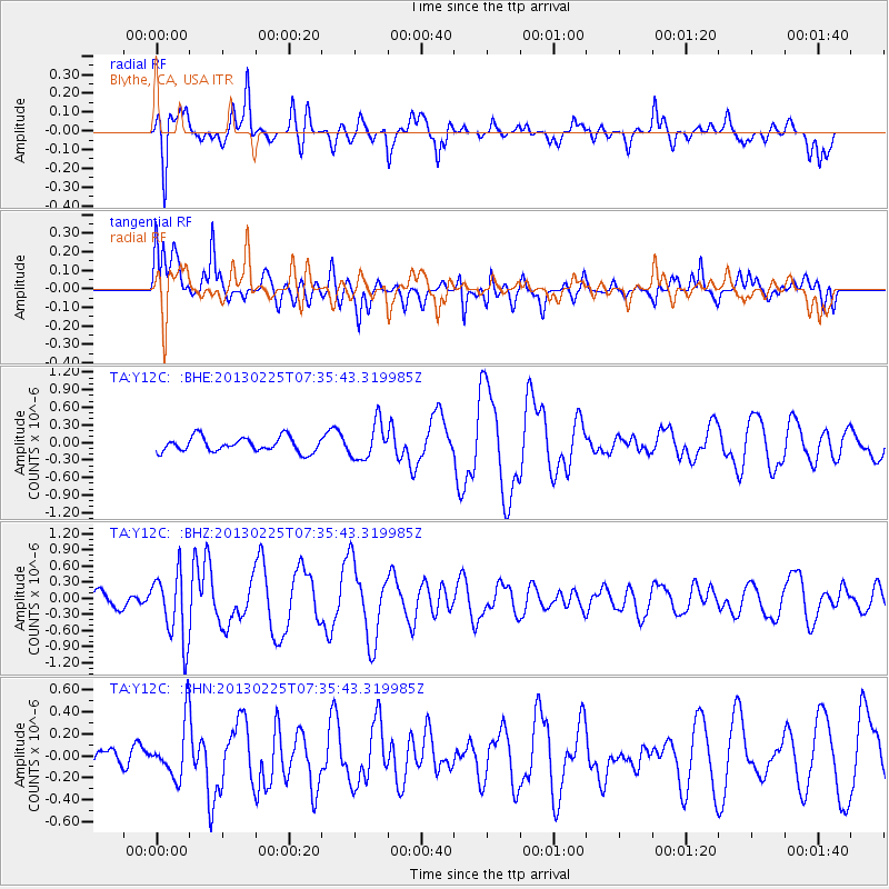
Y12C Blythe, CA, USA - Earthquake Result Viewer
*The percent match for this event was below the threshold and hence no stack was calculated.
| Earthquake location: |
Eastern Honshu, Japan |
| Earthquake latitude/longitude: |
36.8/139.2 |
| Earthquake time(UTC): |
2013/02/25 (056) 07:23:55 GMT |
| Earthquake Depth: |
10 km |
| Earthquake Magnitude: |
5.9 MB, 5.6 MS, 5.8 MW, 5.7 MW |
| Earthquake Catalog/Contributor: |
WHDF/NEIC |
|
| Network: |
TA USArray Transportable Network (new EarthScope stations) |
| Station: |
Y12C Blythe, CA, USA |
| Lat/Lon: |
33.75 N/114.52 W |
| Elevation: |
196 m |
|
| Distance: |
81.8 deg |
| Az: |
53.932 deg |
| Baz: |
308.898 deg |
| Ray Param: |
$rayparam |
*The percent match for this event was below the threshold and hence was not used in the summary stack. |
|
| Radial Match: |
70.13957 % |
| Radial Bump: |
377 |
| Transverse Match: |
76.295044 % |
| Transverse Bump: |
400 |
| SOD ConfigId: |
494114 |
| Insert Time: |
2013-05-09 05:59:16.035 +0000 |
| GWidth: |
2.5 |
| Max Bumps: |
400 |
| Tol: |
0.001 |
|
Signal To Noise
| Channel | StoN | STA | LTA |
| TA:Y12C: :BHZ:20130225T07:35:43.319985Z | 2.2817852 | 6.347338E-7 | 2.7817418E-7 |
| TA:Y12C: :BHN:20130225T07:35:43.319985Z | 1.7761292 | 2.4891077E-7 | 1.4014226E-7 |
| TA:Y12C: :BHE:20130225T07:35:43.319985Z | 2.4662645 | 3.0665265E-7 | 1.2433891E-7 |
| Arrivals |
| Ps | |
| PpPs | |
| PsPs/PpSs | |


