You are here: Home > Network List > TA - USArray Transportable Network (new EarthScope stations) Stations List
> Station P42A Winchester, IL, USA > Earthquake Result Viewer
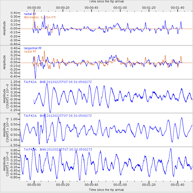
P42A Winchester, IL, USA - Earthquake Result Viewer
*The percent match for this event was below the threshold and hence no stack was calculated.
| Earthquake location: |
Eastern Honshu, Japan |
| Earthquake latitude/longitude: |
36.8/139.2 |
| Earthquake time(UTC): |
2013/02/25 (056) 07:23:55 GMT |
| Earthquake Depth: |
10 km |
| Earthquake Magnitude: |
5.9 MB, 5.6 MS, 5.8 MW, 5.7 MW |
| Earthquake Catalog/Contributor: |
WHDF/NEIC |
|
| Network: |
TA USArray Transportable Network (new EarthScope stations) |
| Station: |
P42A Winchester, IL, USA |
| Lat/Lon: |
39.59 N/90.34 W |
| Elevation: |
197 m |
|
| Distance: |
91.3 deg |
| Az: |
36.055 deg |
| Baz: |
322.34 deg |
| Ray Param: |
$rayparam |
*The percent match for this event was below the threshold and hence was not used in the summary stack. |
|
| Radial Match: |
66.45901 % |
| Radial Bump: |
400 |
| Transverse Match: |
77.44241 % |
| Transverse Bump: |
400 |
| SOD ConfigId: |
494114 |
| Insert Time: |
2013-05-09 06:01:48.824 +0000 |
| GWidth: |
2.5 |
| Max Bumps: |
400 |
| Tol: |
0.001 |
|
Signal To Noise
| Channel | StoN | STA | LTA |
| TA:P42A: :BHZ:20130225T07:36:30.050027Z | 0.8799376 | 5.5070944E-7 | 6.2585053E-7 |
| TA:P42A: :BHN:20130225T07:36:30.050027Z | 1.4837706 | 6.237662E-7 | 4.2039258E-7 |
| TA:P42A: :BHE:20130225T07:36:30.050027Z | 0.8387062 | 4.4727278E-7 | 5.33289E-7 |
| Arrivals |
| Ps | |
| PpPs | |
| PsPs/PpSs | |


