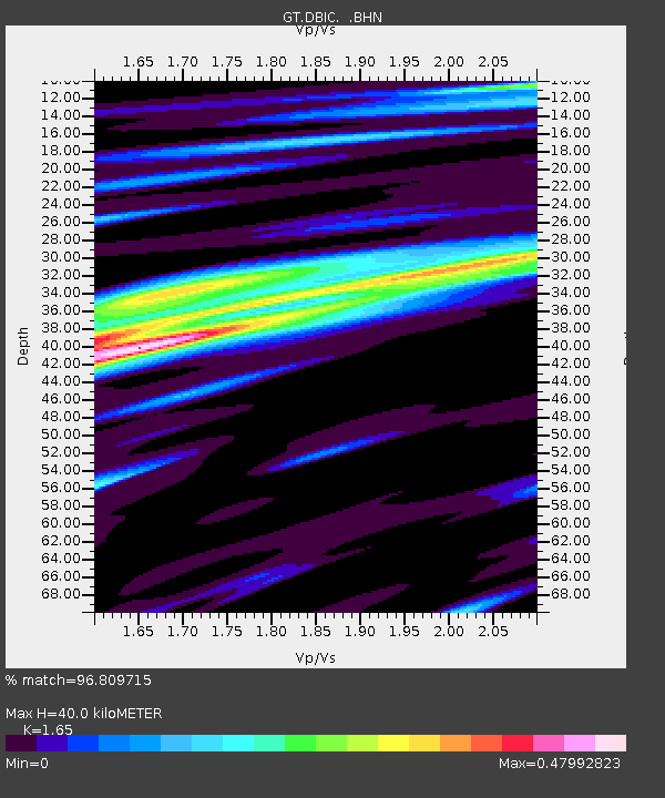
DBIC Dimbokro, Cote d'Ivoire - Earthquake Result Viewer
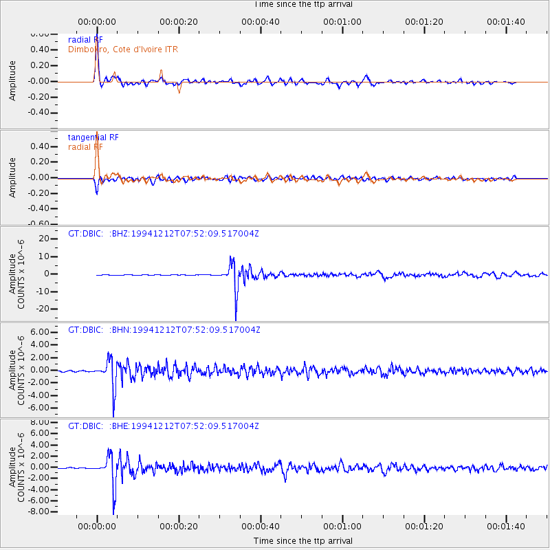
Earthquake location: Peru-Bolivia Border Region
Earthquake latitude/longitude: -17.5/-69.7
Earthquake time(UTC): 1994/12/12 (346) 07:41:55 GMT
Earthquake Depth: 151 km
Earthquake Magnitude: 5.8 MB, 6.1 UNKNOWN, 6.3 MW
Earthquake Catalog/Contributor: WHDF/NEIC
Network: GT Global Telemetered Seismograph Network (USAF/USGS)
Station: DBIC Dimbokro, Cote d'Ivoire
Lat/Lon: 6.67 N/4.86 W
Elevation: 125 m
Distance: 68.3 deg
Az: 75.253 deg
Baz: 248.286 deg
Ray Param: 0.05596047
Estimated Moho Depth: 40.0 km
Estimated Crust Vp/Vs: 1.65
Assumed Crust Vp: 6.419 km/s
Estimated Crust Vs: 3.89 km/s
Estimated Crust Poisson's Ratio: 0.21
Radial Match: 96.809715 %
Radial Bump: 346
Transverse Match: 92.19667 %
Transverse Bump: 400
SOD ConfigId: 16938
Insert Time: 2010-02-27 01:53:12.791 +0000
GWidth: 2.5
Max Bumps: 400
Tol: 0.001

Signal To Noise

ChannelStoNSTALTA
GT:DBIC: :BHN:19941212T07:52:09.517004Z35.6873972.2329411E-66.256946E-8
GT:DBIC: :BHE:19941212T07:52:09.517004Z36.5928542.711111E-67.408854E-8
GT:DBIC: :BHZ:19941212T07:52:09.517004Z91.913177.6751585E-68.350445E-8
Arrivals
Ps4.2 SECOND
PpPs16 SECOND
PsPs/PpSs20 SECOND