You are here: Home > Network List > UW - Pacific Northwest Regional Seismic Network Stations List
> Station UMAT Pilot Rock, OR, USA > Earthquake Result Viewer
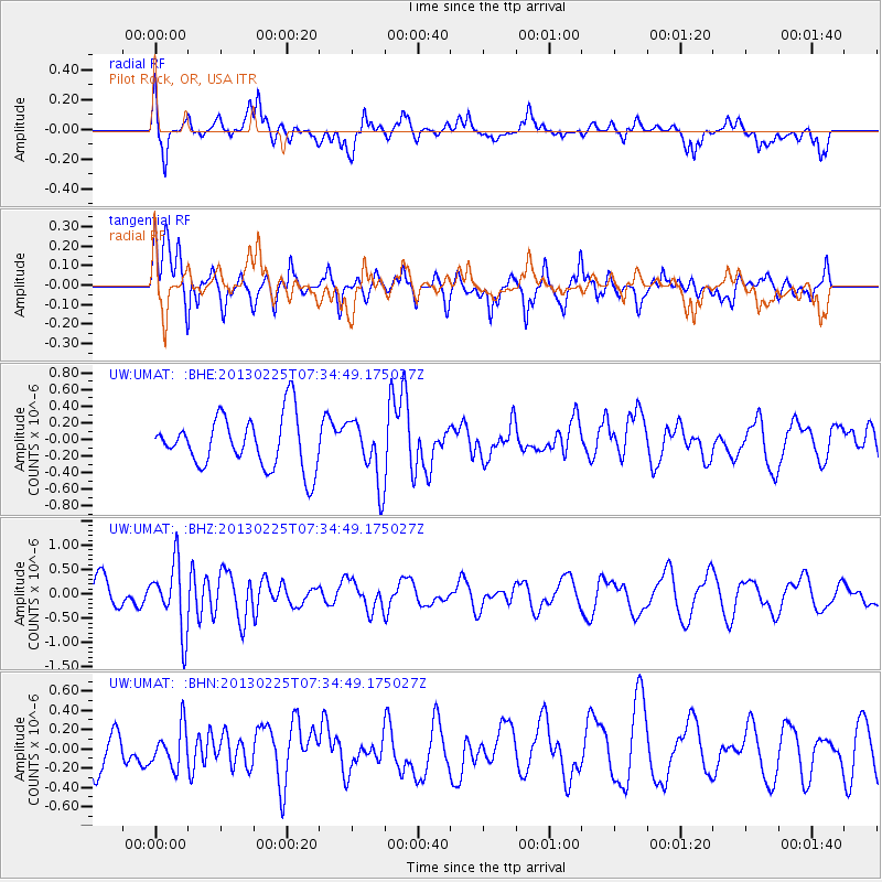
UMAT Pilot Rock, OR, USA - Earthquake Result Viewer
*The percent match for this event was below the threshold and hence no stack was calculated.
| Earthquake location: |
Eastern Honshu, Japan |
| Earthquake latitude/longitude: |
36.8/139.2 |
| Earthquake time(UTC): |
2013/02/25 (056) 07:23:55 GMT |
| Earthquake Depth: |
10 km |
| Earthquake Magnitude: |
5.9 MB, 5.6 MS, 5.8 MW, 5.7 MW |
| Earthquake Catalog/Contributor: |
WHDF/NEIC |
|
| Network: |
UW Pacific Northwest Regional Seismic Network |
| Station: |
UMAT Pilot Rock, OR, USA |
| Lat/Lon: |
45.29 N/118.96 W |
| Elevation: |
1318 m |
|
| Distance: |
72.1 deg |
| Az: |
46.559 deg |
| Baz: |
304.397 deg |
| Ray Param: |
$rayparam |
*The percent match for this event was below the threshold and hence was not used in the summary stack. |
|
| Radial Match: |
66.94135 % |
| Radial Bump: |
400 |
| Transverse Match: |
65.39509 % |
| Transverse Bump: |
400 |
| SOD ConfigId: |
494114 |
| Insert Time: |
2013-05-09 06:06:25.198 +0000 |
| GWidth: |
2.5 |
| Max Bumps: |
400 |
| Tol: |
0.001 |
|
Signal To Noise
| Channel | StoN | STA | LTA |
| UW:UMAT: :BHZ:20130225T07:34:49.175027Z | 2.844912 | 6.8680527E-7 | 2.414153E-7 |
| UW:UMAT: :BHN:20130225T07:34:49.175027Z | 1.0189011 | 2.0572655E-7 | 2.0191021E-7 |
| UW:UMAT: :BHE:20130225T07:34:49.175027Z | 1.1923116 | 3.7236873E-7 | 3.1230823E-7 |
| Arrivals |
| Ps | |
| PpPs | |
| PsPs/PpSs | |


