You are here: Home > Network List > CI - Caltech Regional Seismic Network Stations List
> Station BFS Mt Baldy Forest Station > Earthquake Result Viewer
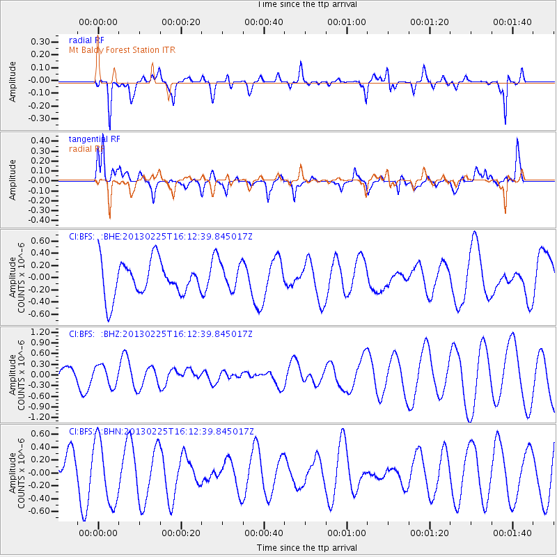
BFS Mt Baldy Forest Station - Earthquake Result Viewer
*The percent match for this event was below the threshold and hence no stack was calculated.
| Earthquake location: |
Southeast Of Ryukyu Islands |
| Earthquake latitude/longitude: |
29.0/131.5 |
| Earthquake time(UTC): |
2013/02/25 (056) 16:00:19 GMT |
| Earthquake Depth: |
46 km |
| Earthquake Magnitude: |
5.5 MB, 5.4 MW |
| Earthquake Catalog/Contributor: |
WHDF/NEIC |
|
| Network: |
CI Caltech Regional Seismic Network |
| Station: |
BFS Mt Baldy Forest Station |
| Lat/Lon: |
34.24 N/117.66 W |
| Elevation: |
1312 m |
|
| Distance: |
89.3 deg |
| Az: |
50.744 deg |
| Baz: |
305.047 deg |
| Ray Param: |
$rayparam |
*The percent match for this event was below the threshold and hence was not used in the summary stack. |
|
| Radial Match: |
59.213516 % |
| Radial Bump: |
343 |
| Transverse Match: |
66.71978 % |
| Transverse Bump: |
400 |
| SOD ConfigId: |
494114 |
| Insert Time: |
2013-05-09 06:10:27.415 +0000 |
| GWidth: |
2.5 |
| Max Bumps: |
400 |
| Tol: |
0.001 |
|
Signal To Noise
| Channel | StoN | STA | LTA |
| CI:BFS: :BHZ:20130225T16:12:39.845017Z | 1.3251141 | 2.882239E-7 | 2.1750876E-7 |
| CI:BFS: :BHN:20130225T16:12:39.845017Z | 2.0138748 | 5.0073874E-7 | 2.486444E-7 |
| CI:BFS: :BHE:20130225T16:12:39.845017Z | 0.7608464 | 2.1514383E-7 | 2.827691E-7 |
| Arrivals |
| Ps | |
| PpPs | |
| PsPs/PpSs | |


