You are here: Home > Network List > TA - USArray Transportable Network (new EarthScope stations) Stations List
> Station G03D McMinnville, OR, USA > Earthquake Result Viewer
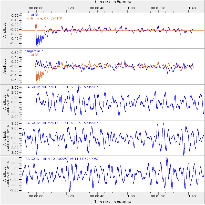
G03D McMinnville, OR, USA - Earthquake Result Viewer
*The percent match for this event was below the threshold and hence no stack was calculated.
| Earthquake location: |
Southeast Of Ryukyu Islands |
| Earthquake latitude/longitude: |
29.0/131.5 |
| Earthquake time(UTC): |
2013/02/25 (056) 16:00:19 GMT |
| Earthquake Depth: |
46 km |
| Earthquake Magnitude: |
5.5 MB, 5.4 MW |
| Earthquake Catalog/Contributor: |
WHDF/NEIC |
|
| Network: |
TA USArray Transportable Network (new EarthScope stations) |
| Station: |
G03D McMinnville, OR, USA |
| Lat/Lon: |
45.21 N/123.26 W |
| Elevation: |
222 m |
|
| Distance: |
79.7 deg |
| Az: |
43.883 deg |
| Baz: |
300.801 deg |
| Ray Param: |
$rayparam |
*The percent match for this event was below the threshold and hence was not used in the summary stack. |
|
| Radial Match: |
54.85931 % |
| Radial Bump: |
400 |
| Transverse Match: |
52.18462 % |
| Transverse Bump: |
400 |
| SOD ConfigId: |
494114 |
| Insert Time: |
2013-05-09 06:12:45.063 +0000 |
| GWidth: |
2.5 |
| Max Bumps: |
400 |
| Tol: |
0.001 |
|
Signal To Noise
| Channel | StoN | STA | LTA |
| TA:G03D: :BHZ:20130225T16:11:51.574998Z | 1.4812723 | 1.5221021E-6 | 1.027564E-6 |
| TA:G03D: :BHN:20130225T16:11:51.574998Z | 0.92734516 | 1.0166023E-6 | 1.0962501E-6 |
| TA:G03D: :BHE:20130225T16:11:51.574998Z | 1.2759235 | 1.4094454E-6 | 1.1046473E-6 |
| Arrivals |
| Ps | |
| PpPs | |
| PsPs/PpSs | |


