You are here: Home > Network List > TA - USArray Transportable Network (new EarthScope stations) Stations List
> Station G38A Ridgeland, WI, USA > Earthquake Result Viewer
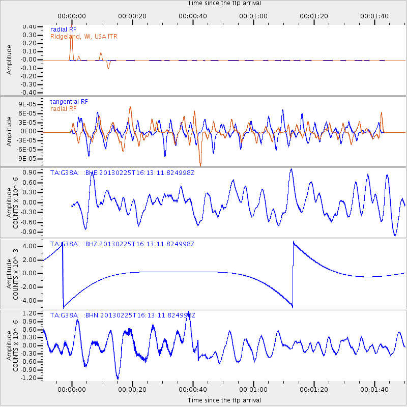
G38A Ridgeland, WI, USA - Earthquake Result Viewer
*The percent match for this event was below the threshold and hence no stack was calculated.
| Earthquake location: |
Southeast Of Ryukyu Islands |
| Earthquake latitude/longitude: |
29.0/131.5 |
| Earthquake time(UTC): |
2013/02/25 (056) 16:00:19 GMT |
| Earthquake Depth: |
46 km |
| Earthquake Magnitude: |
5.5 MB, 5.4 MW |
| Earthquake Catalog/Contributor: |
WHDF/NEIC |
|
| Network: |
TA USArray Transportable Network (new EarthScope stations) |
| Station: |
G38A Ridgeland, WI, USA |
| Lat/Lon: |
45.17 N/91.85 W |
| Elevation: |
370 m |
|
| Distance: |
96.3 deg |
| Az: |
29.25 deg |
| Baz: |
322.77 deg |
| Ray Param: |
$rayparam |
*The percent match for this event was below the threshold and hence was not used in the summary stack. |
|
| Radial Match: |
39.655403 % |
| Radial Bump: |
393 |
| Transverse Match: |
53.147396 % |
| Transverse Bump: |
400 |
| SOD ConfigId: |
494114 |
| Insert Time: |
2013-05-09 06:12:59.762 +0000 |
| GWidth: |
2.5 |
| Max Bumps: |
400 |
| Tol: |
0.001 |
|
Signal To Noise
| Channel | StoN | STA | LTA |
| TA:G38A: :BHZ:20130225T16:13:11.824998Z | 6.1459374 | 0.0046964474 | 7.641548E-4 |
| TA:G38A: :BHN:20130225T16:13:11.824998Z | 1.188883 | 5.6583065E-7 | 4.7593466E-7 |
| TA:G38A: :BHE:20130225T16:13:11.824998Z | 0.6013575 | 2.0654635E-7 | 3.4346678E-7 |
| Arrivals |
| Ps | |
| PpPs | |
| PsPs/PpSs | |


