You are here: Home > Network List > TA - USArray Transportable Network (new EarthScope stations) Stations List
> Station F38A Pierce - Schroeder Farm, Trego, WI, USA > Earthquake Result Viewer
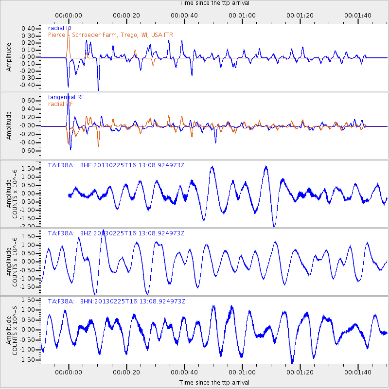
F38A Pierce - Schroeder Farm, Trego, WI, USA - Earthquake Result Viewer
*The percent match for this event was below the threshold and hence no stack was calculated.
| Earthquake location: |
Southeast Of Ryukyu Islands |
| Earthquake latitude/longitude: |
29.0/131.5 |
| Earthquake time(UTC): |
2013/02/25 (056) 16:00:19 GMT |
| Earthquake Depth: |
46 km |
| Earthquake Magnitude: |
5.5 MB, 5.4 MW |
| Earthquake Catalog/Contributor: |
WHDF/NEIC |
|
| Network: |
TA USArray Transportable Network (new EarthScope stations) |
| Station: |
F38A Pierce - Schroeder Farm, Trego, WI, USA |
| Lat/Lon: |
45.96 N/91.88 W |
| Elevation: |
321 m |
|
| Distance: |
95.6 deg |
| Az: |
28.782 deg |
| Baz: |
322.803 deg |
| Ray Param: |
$rayparam |
*The percent match for this event was below the threshold and hence was not used in the summary stack. |
|
| Radial Match: |
68.71639 % |
| Radial Bump: |
400 |
| Transverse Match: |
73.20632 % |
| Transverse Bump: |
400 |
| SOD ConfigId: |
494114 |
| Insert Time: |
2013-05-09 06:13:04.286 +0000 |
| GWidth: |
2.5 |
| Max Bumps: |
400 |
| Tol: |
0.001 |
|
Signal To Noise
| Channel | StoN | STA | LTA |
| TA:F38A: :BHZ:20130225T16:13:08.924973Z | 2.258457 | 9.065743E-7 | 4.0141316E-7 |
| TA:F38A: :BHN:20130225T16:13:08.924973Z | 0.99454474 | 4.674617E-7 | 4.7002578E-7 |
| TA:F38A: :BHE:20130225T16:13:08.924973Z | 1.214535 | 4.120188E-7 | 3.3924E-7 |
| Arrivals |
| Ps | |
| PpPs | |
| PsPs/PpSs | |


