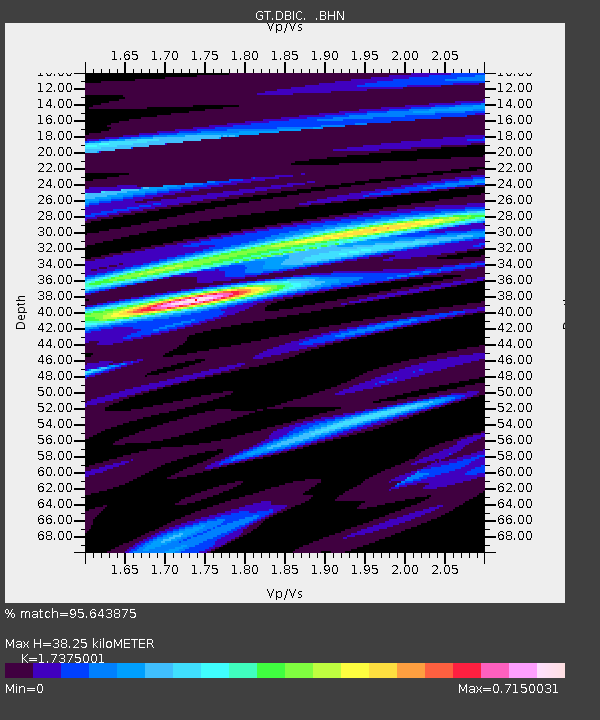
DBIC Dimbokro, Cote d'Ivoire - Earthquake Result Viewer
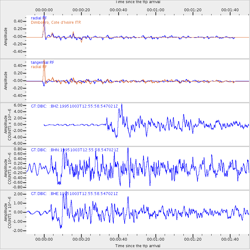
Earthquake location: Peru-Ecuador Border Region
Earthquake latitude/longitude: -2.8/-77.9
Earthquake time(UTC): 1995/10/03 (276) 12:45:00 GMT
Earthquake Depth: 33 km
Earthquake Magnitude: 6.0 MB, 6.1 MS, 5.9 UNKNOWN, 6.4 MW
Earthquake Catalog/Contributor: WHDF/NEIC
Network: GT Global Telemetered Seismograph Network (USAF/USGS)
Station: DBIC Dimbokro, Cote d'Ivoire
Lat/Lon: 6.67 N/4.86 W
Elevation: 125 m
Distance: 73.5 deg
Az: 82.245 deg
Baz: 265.089 deg
Ray Param: 0.052904896
Estimated Moho Depth: 38.25 km
Estimated Crust Vp/Vs: 1.74
Assumed Crust Vp: 6.419 km/s
Estimated Crust Vs: 3.695 km/s
Estimated Crust Poisson's Ratio: 0.25
Radial Match: 95.643875 %
Radial Bump: 366
Transverse Match: 75.58626 %
Transverse Bump: 400
SOD ConfigId: 6273
Insert Time: 2010-02-27 01:53:22.748 +0000
GWidth: 2.5
Max Bumps: 400
Tol: 0.001

Signal To Noise

ChannelStoNSTALTA
GT:DBIC: :BHN:19951003T12:55:58.547021Z1.33737661.705198E-71.275032E-7
GT:DBIC: :BHE:19951003T12:55:58.547021Z3.5472723.2934574E-79.284479E-8
GT:DBIC: :BHZ:19951003T12:55:58.547021Z5.0933466.6227733E-71.3002794E-7
Arrivals
Ps4.5 SECOND
PpPs16 SECOND
PsPs/PpSs20 SECOND