You are here: Home > Network List > TA - USArray Transportable Network (new EarthScope stations) Stations List
> Station E40A Wakefield, MI, USA > Earthquake Result Viewer
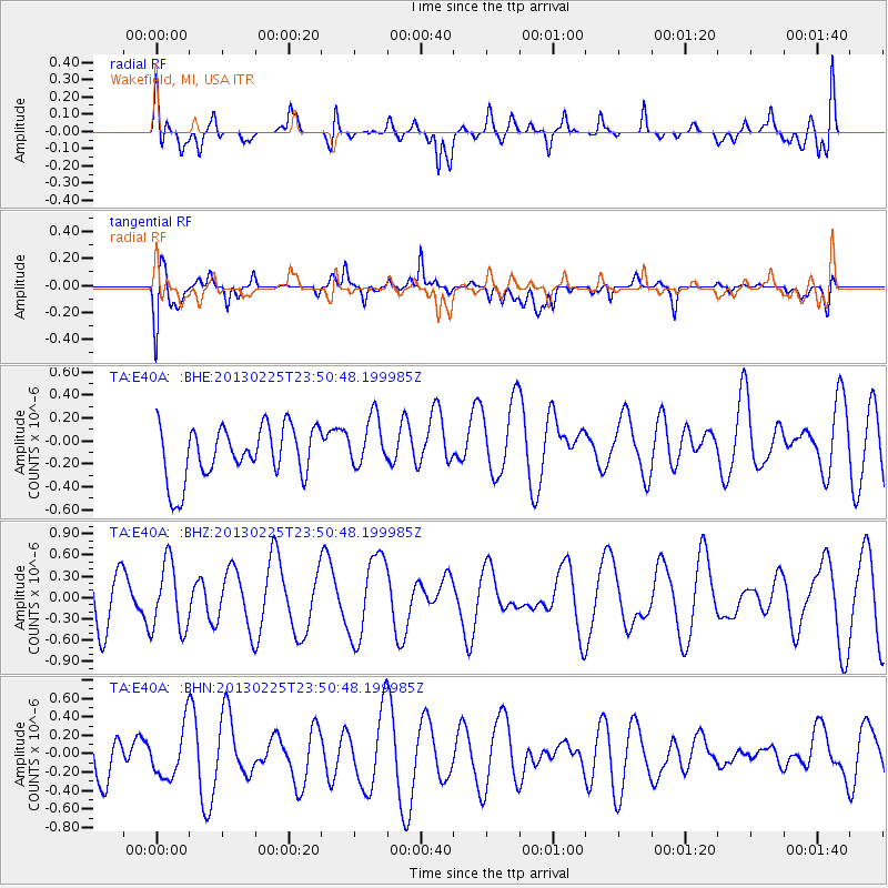
E40A Wakefield, MI, USA - Earthquake Result Viewer
*The percent match for this event was below the threshold and hence no stack was calculated.
| Earthquake location: |
Southern Pacific Ocean |
| Earthquake latitude/longitude: |
-48.4/-87.1 |
| Earthquake time(UTC): |
2013/02/25 (056) 23:37:59 GMT |
| Earthquake Depth: |
10 km |
| Earthquake Magnitude: |
5.5 MB, 4.8 MS, 5.2 MW |
| Earthquake Catalog/Contributor: |
WHDF/NEIC |
|
| Network: |
TA USArray Transportable Network (new EarthScope stations) |
| Station: |
E40A Wakefield, MI, USA |
| Lat/Lon: |
46.44 N/89.90 W |
| Elevation: |
472 m |
|
| Distance: |
94.5 deg |
| Az: |
358.075 deg |
| Baz: |
178.144 deg |
| Ray Param: |
$rayparam |
*The percent match for this event was below the threshold and hence was not used in the summary stack. |
|
| Radial Match: |
49.92915 % |
| Radial Bump: |
400 |
| Transverse Match: |
64.65404 % |
| Transverse Bump: |
400 |
| SOD ConfigId: |
494114 |
| Insert Time: |
2013-05-09 06:19:09.804 +0000 |
| GWidth: |
2.5 |
| Max Bumps: |
400 |
| Tol: |
0.001 |
|
Signal To Noise
| Channel | StoN | STA | LTA |
| TA:E40A: :BHZ:20130225T23:50:48.199985Z | 1.1027701 | 4.7437945E-7 | 4.3017076E-7 |
| TA:E40A: :BHN:20130225T23:50:48.199985Z | 0.9460508 | 2.8010638E-7 | 2.9607963E-7 |
| TA:E40A: :BHE:20130225T23:50:48.199985Z | 0.9743649 | 2.2273333E-7 | 2.2859335E-7 |
| Arrivals |
| Ps | |
| PpPs | |
| PsPs/PpSs | |


