You are here: Home > Network List > TA - USArray Transportable Network (new EarthScope stations) Stations List
> Station R53A Hurricane, WV, USA > Earthquake Result Viewer
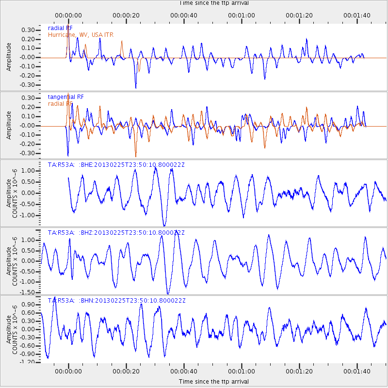
R53A Hurricane, WV, USA - Earthquake Result Viewer
*The percent match for this event was below the threshold and hence no stack was calculated.
| Earthquake location: |
Southern Pacific Ocean |
| Earthquake latitude/longitude: |
-48.4/-87.1 |
| Earthquake time(UTC): |
2013/02/25 (056) 23:37:59 GMT |
| Earthquake Depth: |
10 km |
| Earthquake Magnitude: |
5.5 MB, 4.8 MS, 5.2 MW |
| Earthquake Catalog/Contributor: |
WHDF/NEIC |
|
| Network: |
TA USArray Transportable Network (new EarthScope stations) |
| Station: |
R53A Hurricane, WV, USA |
| Lat/Lon: |
38.33 N/81.95 W |
| Elevation: |
294 m |
|
| Distance: |
86.5 deg |
| Az: |
4.073 deg |
| Baz: |
183.452 deg |
| Ray Param: |
$rayparam |
*The percent match for this event was below the threshold and hence was not used in the summary stack. |
|
| Radial Match: |
65.212555 % |
| Radial Bump: |
400 |
| Transverse Match: |
58.151375 % |
| Transverse Bump: |
400 |
| SOD ConfigId: |
494114 |
| Insert Time: |
2013-05-09 06:21:58.447 +0000 |
| GWidth: |
2.5 |
| Max Bumps: |
400 |
| Tol: |
0.001 |
|
Signal To Noise
| Channel | StoN | STA | LTA |
| TA:R53A: :BHZ:20130225T23:50:10.800022Z | 0.9897336 | 4.6593047E-7 | 4.7076352E-7 |
| TA:R53A: :BHN:20130225T23:50:10.800022Z | 0.8371783 | 2.9782476E-7 | 3.557483E-7 |
| TA:R53A: :BHE:20130225T23:50:10.800022Z | 1.9313964 | 8.8029174E-7 | 4.5577994E-7 |
| Arrivals |
| Ps | |
| PpPs | |
| PsPs/PpSs | |


