You are here: Home > Network List > US - United States National Seismic Network Stations List
> Station AMTX Amarillo, Texas, USA > Earthquake Result Viewer
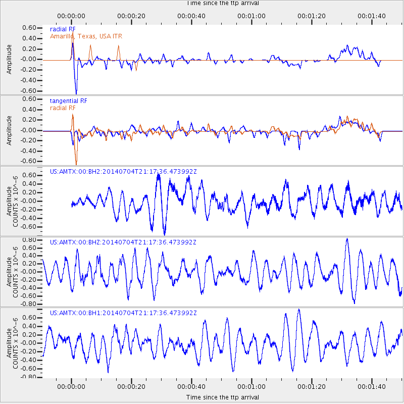
AMTX Amarillo, Texas, USA - Earthquake Result Viewer
*The percent match for this event was below the threshold and hence no stack was calculated.
| Earthquake location: |
Azores Islands Region |
| Earthquake latitude/longitude: |
35.1/-34.9 |
| Earthquake time(UTC): |
2014/07/04 (185) 21:08:45 GMT |
| Earthquake Depth: |
10 km |
| Earthquake Magnitude: |
5.6 MW, 5.2 mb, 5.0 Ms_20, 5.4 Mwb, 5.6 Mwc |
| Earthquake Catalog/Contributor: |
ISC/ISC |
|
| Network: |
US United States National Seismic Network |
| Station: |
AMTX Amarillo, Texas, USA |
| Lat/Lon: |
34.53 N/101.41 W |
| Elevation: |
1010 m |
|
| Distance: |
53.6 deg |
| Az: |
289.927 deg |
| Baz: |
69.06 deg |
| Ray Param: |
$rayparam |
*The percent match for this event was below the threshold and hence was not used in the summary stack. |
|
| Radial Match: |
66.09034 % |
| Radial Bump: |
400 |
| Transverse Match: |
42.88717 % |
| Transverse Bump: |
400 |
| SOD ConfigId: |
3390531 |
| Insert Time: |
2019-04-12 16:56:07.334 +0000 |
| GWidth: |
2.5 |
| Max Bumps: |
400 |
| Tol: |
0.001 |
|
Signal To Noise
| Channel | StoN | STA | LTA |
| US:AMTX:00:BHZ:20140704T21:17:36.473992Z | 1.6276922 | 2.9585922E-7 | 1.8176607E-7 |
| US:AMTX:00:BH1:20140704T21:17:36.473992Z | 0.7647161 | 2.2012556E-7 | 2.8785266E-7 |
| US:AMTX:00:BH2:20140704T21:17:36.473992Z | 2.7541919 | 4.6937993E-7 | 1.7042383E-7 |
| Arrivals |
| Ps | |
| PpPs | |
| PsPs/PpSs | |


