You are here: Home > Network List > UU - University of Utah Regional Network Stations List
> Station ASI2 Darling Creek, Challis, ID, USA > Earthquake Result Viewer
ASI2 Darling Creek, Challis, ID, USA - Earthquake Result Viewer
| Earthquake location: |
Azores Islands Region |
| Earthquake latitude/longitude: |
35.1/-34.9 |
| Earthquake time(UTC): |
2014/07/04 (185) 21:08:45 GMT |
| Earthquake Depth: |
10 km |
| Earthquake Magnitude: |
5.6 MW, 5.2 mb, 5.0 Ms_20, 5.4 Mwb, 5.6 Mwc |
| Earthquake Catalog/Contributor: |
ISC/ISC |
|
| Network: |
UU University of Utah Regional Network |
| Station: |
ASI2 Darling Creek, Challis, ID, USA |
| Lat/Lon: |
44.57 N/114.26 W |
| Elevation: |
1600 m |
|
| Distance: |
59.4 deg |
| Az: |
305.344 deg |
| Baz: |
69.405 deg |
| Ray Param: |
0.06218738 |
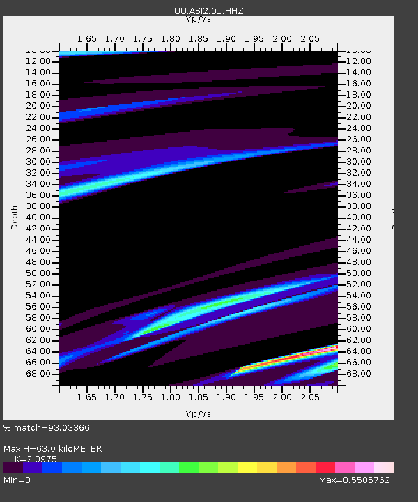
| Estimated Moho Depth: |
63.0 km |
| Estimated Crust Vp/Vs: |
2.10 |
| Assumed Crust Vp: |
6.577 km/s |
| Estimated Crust Vs: |
3.136 km/s |
| Estimated Crust Poisson's Ratio: |
0.35 |
|
| Radial Match: |
93.03366 % |
| Radial Bump: |
200 |
| Transverse Match: |
74.668015 % |
| Transverse Bump: |
320 |
| SOD ConfigId: |
3390531 |
| Insert Time: |
2019-04-12 16:56:18.407 +0000 |
| GWidth: |
2.5 |
| Max Bumps: |
400 |
| Tol: |
0.001 |
|

Signal To Noise
| Channel | StoN | STA | LTA |
| UU:ASI2:01:HHZ:20140704T21:18:17.017998Z | 2.679501 | 4.0886334E-8 | 1.5258937E-8 |
| UU:ASI2:01:HHN:20140704T21:18:17.017998Z | 0.98966247 | 7.8103454E-8 | 7.8919285E-8 |
| UU:ASI2:01:HHE:20140704T21:18:17.017998Z | 2.1536932 | 3.93629E-8 | 1.827693E-8 |
| Arrivals |
| Ps | 11 SECOND |
| PpPs | 28 SECOND |
| PsPs/PpSs | 39 SECOND |


