You are here: Home > Network List > TA - USArray Transportable Network (new EarthScope stations) Stations List
> Station J01E Myrtle Point, OR, USA > Earthquake Result Viewer
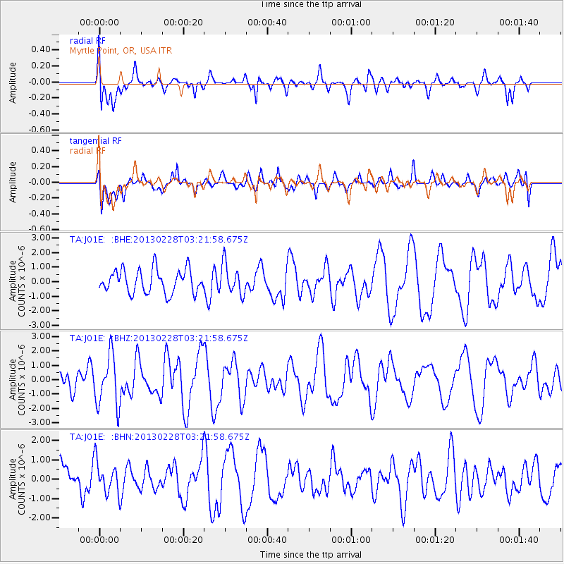
J01E Myrtle Point, OR, USA - Earthquake Result Viewer
*The percent match for this event was below the threshold and hence no stack was calculated.
| Earthquake location: |
Vanuatu Islands |
| Earthquake latitude/longitude: |
-17.7/167.3 |
| Earthquake time(UTC): |
2013/02/28 (059) 03:09:44 GMT |
| Earthquake Depth: |
18 km |
| Earthquake Magnitude: |
6.0 MB, 5.7 MS, 5.9 MW, 5.7 MW |
| Earthquake Catalog/Contributor: |
WHDF/NEIC |
|
| Network: |
TA USArray Transportable Network (new EarthScope stations) |
| Station: |
J01E Myrtle Point, OR, USA |
| Lat/Lon: |
43.16 N/123.93 W |
| Elevation: |
128 m |
|
| Distance: |
87.3 deg |
| Az: |
43.049 deg |
| Baz: |
242.772 deg |
| Ray Param: |
$rayparam |
*The percent match for this event was below the threshold and hence was not used in the summary stack. |
|
| Radial Match: |
64.36841 % |
| Radial Bump: |
343 |
| Transverse Match: |
54.272903 % |
| Transverse Bump: |
400 |
| SOD ConfigId: |
494114 |
| Insert Time: |
2013-05-15 04:41:15.330 +0000 |
| GWidth: |
2.5 |
| Max Bumps: |
400 |
| Tol: |
0.001 |
|
Signal To Noise
| Channel | StoN | STA | LTA |
| TA:J01E: :BHZ:20130228T03:21:58.675Z | 2.2789683 | 1.8254228E-6 | 8.0098647E-7 |
| TA:J01E: :BHN:20130228T03:21:58.675Z | 0.7916088 | 7.725054E-7 | 9.758676E-7 |
| TA:J01E: :BHE:20130228T03:21:58.675Z | 1.3191496 | 1.0541792E-6 | 7.991354E-7 |
| Arrivals |
| Ps | |
| PpPs | |
| PsPs/PpSs | |


