You are here: Home > Network List > AU - Australian Seismological Centre Stations List
> Station RABL Rabaul, Papau New Guinea > Earthquake Result Viewer
RABL Rabaul, Papau New Guinea - Earthquake Result Viewer
| Earthquake location: |
Kuril Islands |
| Earthquake latitude/longitude: |
51.0/157.3 |
| Earthquake time(UTC): |
2013/02/28 (059) 14:05:50 GMT |
| Earthquake Depth: |
41 km |
| Earthquake Magnitude: |
6.4 MB, 6.7 MS, 6.9 MW, 6.8 MW |
| Earthquake Catalog/Contributor: |
WHDF/NEIC |
|
| Network: |
AU Australian Seismological Centre |
| Station: |
RABL Rabaul, Papau New Guinea |
| Lat/Lon: |
4.19 S/152.16 E |
| Elevation: |
277 m |
|
| Distance: |
55.1 deg |
| Az: |
186.229 deg |
| Baz: |
3.946 deg |
| Ray Param: |
0.06492475 |
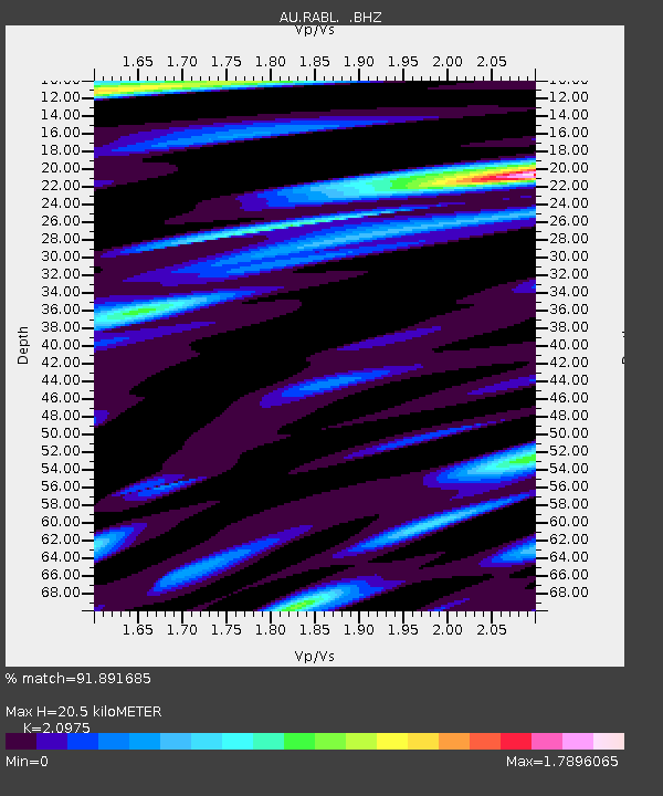
| Estimated Moho Depth: |
20.5 km |
| Estimated Crust Vp/Vs: |
2.10 |
| Assumed Crust Vp: |
6.183 km/s |
| Estimated Crust Vs: |
2.948 km/s |
| Estimated Crust Poisson's Ratio: |
0.35 |
|
| Radial Match: |
91.891685 % |
| Radial Bump: |
400 |
| Transverse Match: |
78.27903 % |
| Transverse Bump: |
400 |
| SOD ConfigId: |
494114 |
| Insert Time: |
2013-05-15 04:46:21.073 +0000 |
| GWidth: |
2.5 |
| Max Bumps: |
400 |
| Tol: |
0.001 |
|

Signal To Noise
| Channel | StoN | STA | LTA |
| AU:RABL: :BHZ:20130228T14:14:47.594971Z | 11.073242 | 4.10122E-6 | 3.703721E-7 |
| AU:RABL: :BHN:20130228T14:14:47.594971Z | 3.308483 | 2.3847313E-6 | 7.20793E-7 |
| AU:RABL: :BHE:20130228T14:14:47.594971Z | 1.2293705 | 1.0629795E-6 | 8.646535E-7 |
| Arrivals |
| Ps | 3.8 SECOND |
| PpPs | 9.9 SECOND |
| PsPs/PpSs | 14 SECOND |


