You are here: Home > Network List > GS - US Geological Survey Networks Stations List
> Station KAN10 Keim Farm > Earthquake Result Viewer
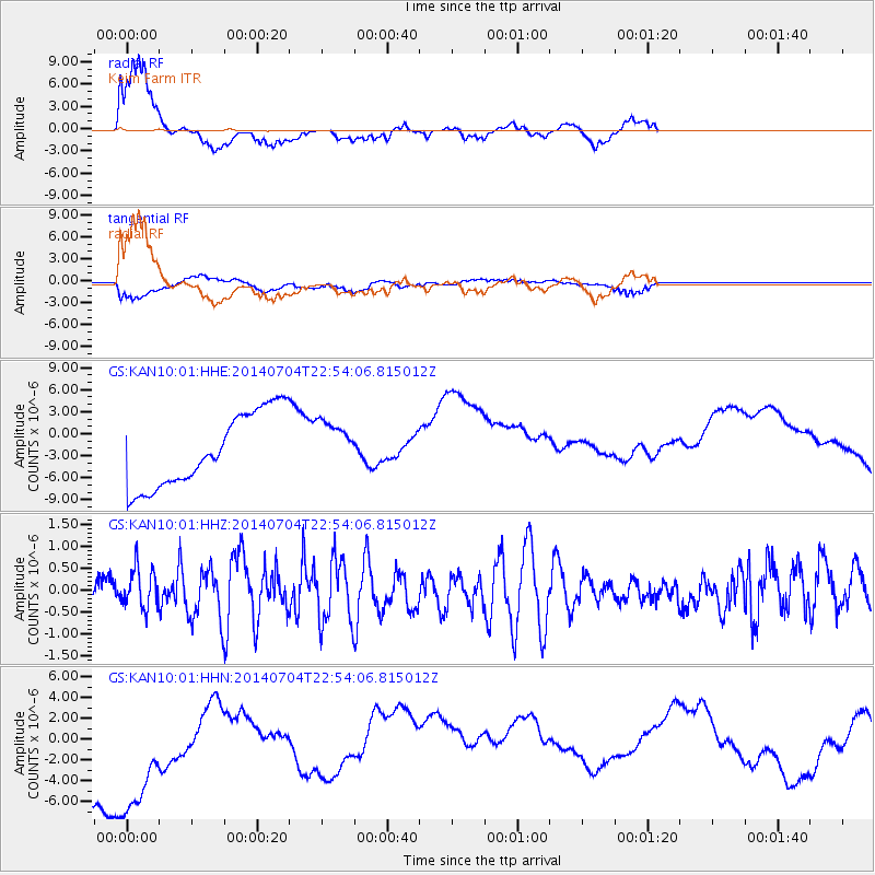
KAN10 Keim Farm - Earthquake Result Viewer
*The percent match for this event was below the threshold and hence no stack was calculated.
| Earthquake location: |
Near East Coast Of Honshu, Japan |
| Earthquake latitude/longitude: |
39.7/142.0 |
| Earthquake time(UTC): |
2014/07/04 (185) 22:42:04 GMT |
| Earthquake Depth: |
45 km |
| Earthquake Magnitude: |
5.7 MB |
| Earthquake Catalog/Contributor: |
NEIC PDE/NEIC COMCAT |
|
| Network: |
GS US Geological Survey Networks |
| Station: |
KAN10 Keim Farm |
| Lat/Lon: |
37.12 N/98.10 W |
| Elevation: |
417 m |
|
| Distance: |
85.7 deg |
| Az: |
44.031 deg |
| Baz: |
317.845 deg |
| Ray Param: |
$rayparam |
*The percent match for this event was below the threshold and hence was not used in the summary stack. |
|
| Radial Match: |
77.55844 % |
| Radial Bump: |
400 |
| Transverse Match: |
33.131157 % |
| Transverse Bump: |
400 |
| SOD ConfigId: |
3390531 |
| Insert Time: |
2019-04-12 17:01:30.676 +0000 |
| GWidth: |
2.5 |
| Max Bumps: |
400 |
| Tol: |
0.001 |
|
Signal To Noise
| Channel | StoN | STA | LTA |
| GS:KAN10:01:HHZ:20140704T22:54:06.815012Z | 1.0808774 | 4.5753842E-7 | 4.233028E-7 |
| GS:KAN10:01:HHN:20140704T22:54:06.815012Z | 1.3800266 | 9.806852E-6 | 7.1062773E-6 |
| GS:KAN10:01:HHE:20140704T22:54:06.815012Z | 0.48585182 | 2.4217031E-6 | 4.984448E-6 |
| Arrivals |
| Ps | |
| PpPs | |
| PsPs/PpSs | |


