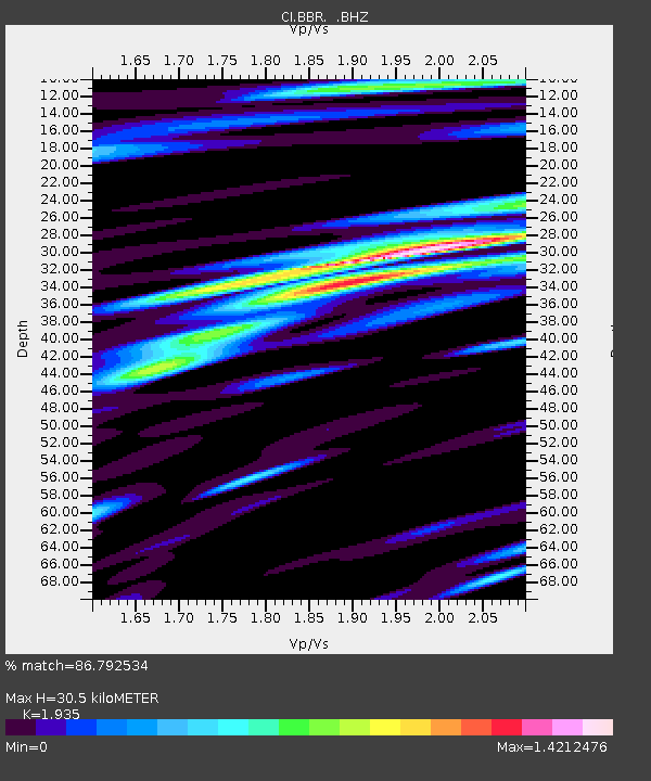
BBR Big Bear Solar Observatory - Earthquake Result Viewer

Earthquake location: Kuril Islands
Earthquake latitude/longitude: 51.0/157.3
Earthquake time(UTC): 2013/02/28 (059) 14:05:50 GMT
Earthquake Depth: 41 km
Earthquake Magnitude: 6.4 MB, 6.7 MS, 6.9 MW, 6.8 MW
Earthquake Catalog/Contributor: WHDF/NEIC
Network: CI Caltech Regional Seismic Network
Station: BBR Big Bear Solar Observatory
Lat/Lon: 34.26 N/116.92 W
Elevation: 2069 m
Distance: 61.8 deg
Az: 69.585 deg
Baz: 314.298 deg
Ray Param: 0.060562495
Estimated Moho Depth: 30.5 km
Estimated Crust Vp/Vs: 1.93
Assumed Crust Vp: 6.276 km/s
Estimated Crust Vs: 3.243 km/s
Estimated Crust Poisson's Ratio: 0.32
Radial Match: 86.792534 %
Radial Bump: 400
Transverse Match: 78.434 %
Transverse Bump: 400
SOD ConfigId: 494114
Insert Time: 2013-05-15 04:52:03.813 +0000
GWidth: 2.5
Max Bumps: 400
Tol: 0.001

Signal To Noise

ChannelStoNSTALTA
CI:BBR: :BHZ:20130228T14:15:34.195007Z10.3896222.6388211E-62.5398626E-7
CI:BBR: :BHN:20130228T14:15:34.195007Z4.43994439.791909E-72.2054125E-7
CI:BBR: :BHE:20130228T14:15:34.195007Z2.70521071.0007283E-63.699262E-7
Arrivals
Ps4.7 SECOND
PpPs14 SECOND
PsPs/PpSs18 SECOND