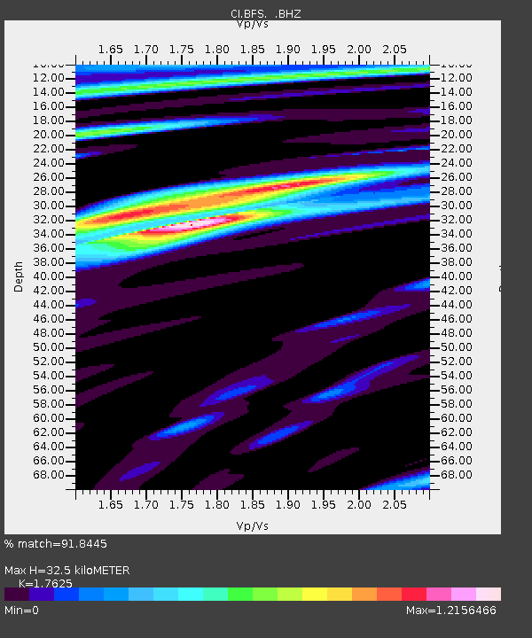
BFS Mt Baldy Forest Station - Earthquake Result Viewer
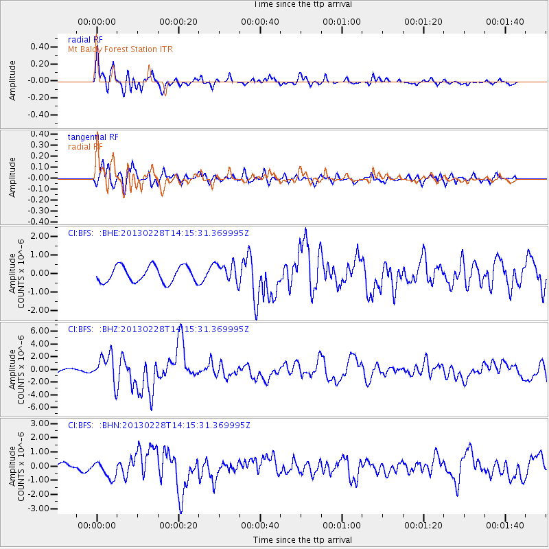
Earthquake location: Kuril Islands
Earthquake latitude/longitude: 51.0/157.3
Earthquake time(UTC): 2013/02/28 (059) 14:05:50 GMT
Earthquake Depth: 41 km
Earthquake Magnitude: 6.4 MB, 6.7 MS, 6.9 MW, 6.8 MW
Earthquake Catalog/Contributor: WHDF/NEIC
Network: CI Caltech Regional Seismic Network
Station: BFS Mt Baldy Forest Station
Lat/Lon: 34.24 N/117.66 W
Elevation: 1312 m
Distance: 61.4 deg
Az: 70.089 deg
Baz: 314.125 deg
Ray Param: 0.06082926
Estimated Moho Depth: 32.5 km
Estimated Crust Vp/Vs: 1.76
Assumed Crust Vp: 6.276 km/s
Estimated Crust Vs: 3.561 km/s
Estimated Crust Poisson's Ratio: 0.26
Radial Match: 91.8445 %
Radial Bump: 400
Transverse Match: 74.61257 %
Transverse Bump: 400
SOD ConfigId: 494114
Insert Time: 2013-05-15 04:52:43.613 +0000
GWidth: 2.5
Max Bumps: 400
Tol: 0.001

Signal To Noise

ChannelStoNSTALTA
CI:BFS: :BHZ:20130228T14:15:31.369995Z5.93166352.26943E-63.8259589E-7
CI:BFS: :BHN:20130228T14:15:31.369995Z1.77273266.141201E-73.4642568E-7
CI:BFS: :BHE:20130228T14:15:31.369995Z1.1947555.1094224E-74.2765444E-7
Arrivals
Ps4.1 SECOND
PpPs14 SECOND
PsPs/PpSs18 SECOND