You are here: Home > Network List > TA - USArray Transportable Network (new EarthScope stations) Stations List
> Station X58A Rowland, NC, USA > Earthquake Result Viewer
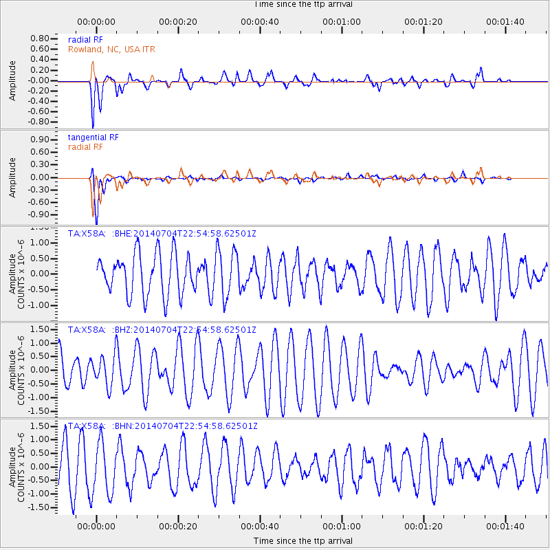
X58A Rowland, NC, USA - Earthquake Result Viewer
*The percent match for this event was below the threshold and hence no stack was calculated.
| Earthquake location: |
Near East Coast Of Honshu, Japan |
| Earthquake latitude/longitude: |
39.7/142.0 |
| Earthquake time(UTC): |
2014/07/04 (185) 22:42:04 GMT |
| Earthquake Depth: |
45 km |
| Earthquake Magnitude: |
5.7 MB |
| Earthquake Catalog/Contributor: |
NEIC PDE/NEIC COMCAT |
|
| Network: |
TA USArray Transportable Network (new EarthScope stations) |
| Station: |
X58A Rowland, NC, USA |
| Lat/Lon: |
34.55 N/79.34 W |
| Elevation: |
45 m |
|
| Distance: |
96.8 deg |
| Az: |
33.328 deg |
| Baz: |
329.085 deg |
| Ray Param: |
$rayparam |
*The percent match for this event was below the threshold and hence was not used in the summary stack. |
|
| Radial Match: |
55.143066 % |
| Radial Bump: |
400 |
| Transverse Match: |
82.907974 % |
| Transverse Bump: |
400 |
| SOD ConfigId: |
3390531 |
| Insert Time: |
2019-04-12 17:04:52.413 +0000 |
| GWidth: |
2.5 |
| Max Bumps: |
400 |
| Tol: |
0.001 |
|
Signal To Noise
| Channel | StoN | STA | LTA |
| TA:X58A: :BHZ:20140704T22:54:58.62501Z | 1.0682421 | 5.979216E-7 | 5.597248E-7 |
| TA:X58A: :BHN:20140704T22:54:58.62501Z | 1.4511489 | 9.0393445E-7 | 6.2290957E-7 |
| TA:X58A: :BHE:20140704T22:54:58.62501Z | 1.0856388 | 6.953802E-7 | 6.405263E-7 |
| Arrivals |
| Ps | |
| PpPs | |
| PsPs/PpSs | |


