You are here: Home > Network List > DK - Danish Seismological Network Stations List
> Station TULEG Thule Air Base, Greenland > Earthquake Result Viewer
TULEG Thule Air Base, Greenland - Earthquake Result Viewer
| Earthquake location: |
Kuril Islands |
| Earthquake latitude/longitude: |
51.0/157.3 |
| Earthquake time(UTC): |
2013/02/28 (059) 14:05:50 GMT |
| Earthquake Depth: |
41 km |
| Earthquake Magnitude: |
6.4 MB, 6.7 MS, 6.9 MW, 6.8 MW |
| Earthquake Catalog/Contributor: |
WHDF/NEIC |
|
| Network: |
DK Danish Seismological Network |
| Station: |
TULEG Thule Air Base, Greenland |
| Lat/Lon: |
76.54 N/68.82 W |
| Elevation: |
38 m |
|
| Distance: |
49.4 deg |
| Az: |
12.841 deg |
| Baz: |
323.133 deg |
| Ray Param: |
0.068608925 |
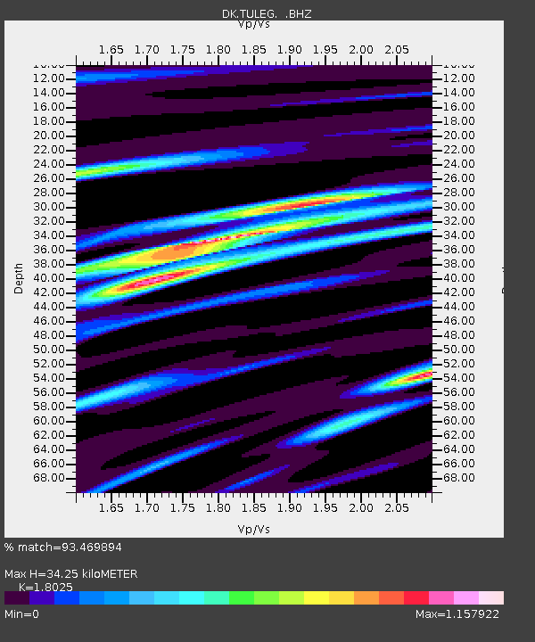
| Estimated Moho Depth: |
34.25 km |
| Estimated Crust Vp/Vs: |
1.80 |
| Assumed Crust Vp: |
6.459 km/s |
| Estimated Crust Vs: |
3.584 km/s |
| Estimated Crust Poisson's Ratio: |
0.28 |
|
| Radial Match: |
93.469894 % |
| Radial Bump: |
368 |
| Transverse Match: |
74.42377 % |
| Transverse Bump: |
400 |
| SOD ConfigId: |
494114 |
| Insert Time: |
2013-05-15 04:55:15.836 +0000 |
| GWidth: |
2.5 |
| Max Bumps: |
400 |
| Tol: |
0.001 |
|

Signal To Noise
| Channel | StoN | STA | LTA |
| DK:TULEG: :BHZ:20130228T14:14:05.649994Z | 15.998396 | 4.6330724E-6 | 2.8959604E-7 |
| DK:TULEG: :BHN:20130228T14:14:05.649994Z | 3.0117836 | 1.8323365E-6 | 6.083892E-7 |
| DK:TULEG: :BHE:20130228T14:14:05.649994Z | 5.1846995 | 1.4381376E-6 | 2.7738108E-7 |
| Arrivals |
| Ps | 4.5 SECOND |
| PpPs | 14 SECOND |
| PsPs/PpSs | 19 SECOND |


