You are here: Home > Network List > DK - Danish Seismological Network Stations List
> Station NUUK Nuuk, Greenland > Earthquake Result Viewer
NUUK Nuuk, Greenland - Earthquake Result Viewer
| Earthquake location: |
Kuril Islands |
| Earthquake latitude/longitude: |
51.0/157.3 |
| Earthquake time(UTC): |
2013/02/28 (059) 14:05:50 GMT |
| Earthquake Depth: |
41 km |
| Earthquake Magnitude: |
6.4 MB, 6.7 MS, 6.9 MW, 6.8 MW |
| Earthquake Catalog/Contributor: |
WHDF/NEIC |
|
| Network: |
DK Danish Seismological Network |
| Station: |
NUUK Nuuk, Greenland |
| Lat/Lon: |
64.18 N/51.67 W |
| Elevation: |
110 m |
|
| Distance: |
63.0 deg |
| Az: |
13.762 deg |
| Baz: |
339.902 deg |
| Ray Param: |
0.0597841 |
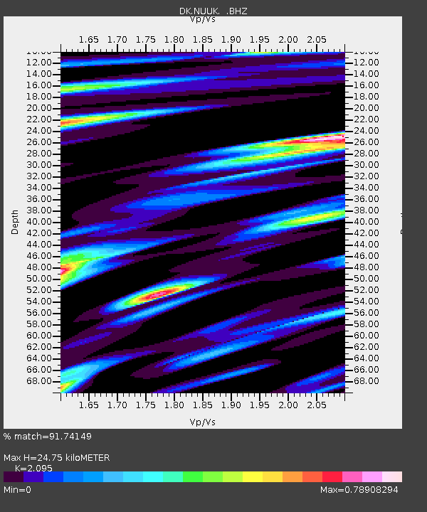
| Estimated Moho Depth: |
24.75 km |
| Estimated Crust Vp/Vs: |
2.10 |
| Assumed Crust Vp: |
6.459 km/s |
| Estimated Crust Vs: |
3.083 km/s |
| Estimated Crust Poisson's Ratio: |
0.35 |
|
| Radial Match: |
91.74149 % |
| Radial Bump: |
400 |
| Transverse Match: |
80.14287 % |
| Transverse Bump: |
400 |
| SOD ConfigId: |
494114 |
| Insert Time: |
2013-05-15 04:55:19.791 +0000 |
| GWidth: |
2.5 |
| Max Bumps: |
400 |
| Tol: |
0.001 |
|

Signal To Noise
| Channel | StoN | STA | LTA |
| DK:NUUK: :BHZ:20130228T14:15:42.150024Z | 8.13177 | 3.6771946E-6 | 4.5220102E-7 |
| DK:NUUK: :BHN:20130228T14:15:42.150024Z | 4.2027464 | 2.2741906E-6 | 5.411201E-7 |
| DK:NUUK: :BHE:20130228T14:15:42.150024Z | 1.5600213 | 6.7061586E-7 | 4.2987608E-7 |
| Arrivals |
| Ps | 4.4 SECOND |
| PpPs | 11 SECOND |
| PsPs/PpSs | 16 SECOND |


