You are here: Home > Network List > IM - International Miscellaneous Stations Stations List
> Station TX32 TXAR Array, Lajitas, TX, USA > Earthquake Result Viewer
TX32 TXAR Array, Lajitas, TX, USA - Earthquake Result Viewer
| Earthquake location: |
Kuril Islands |
| Earthquake latitude/longitude: |
51.0/157.3 |
| Earthquake time(UTC): |
2013/02/28 (059) 14:05:50 GMT |
| Earthquake Depth: |
41 km |
| Earthquake Magnitude: |
6.4 MB, 6.7 MS, 6.9 MW, 6.8 MW |
| Earthquake Catalog/Contributor: |
WHDF/NEIC |
|
| Network: |
IM International Miscellaneous Stations |
| Station: |
TX32 TXAR Array, Lajitas, TX, USA |
| Lat/Lon: |
29.33 N/103.67 W |
| Elevation: |
1013 m |
|
| Distance: |
73.1 deg |
| Az: |
64.318 deg |
| Baz: |
319.247 deg |
| Ray Param: |
0.05315515 |
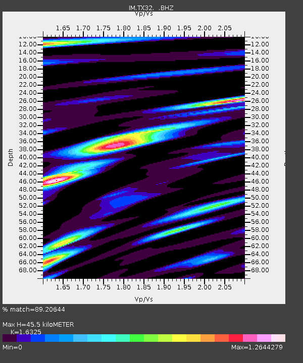
| Estimated Moho Depth: |
45.5 km |
| Estimated Crust Vp/Vs: |
1.63 |
| Assumed Crust Vp: |
6.419 km/s |
| Estimated Crust Vs: |
3.932 km/s |
| Estimated Crust Poisson's Ratio: |
0.20 |
|
| Radial Match: |
89.20644 % |
| Radial Bump: |
400 |
| Transverse Match: |
90.13108 % |
| Transverse Bump: |
400 |
| SOD ConfigId: |
494114 |
| Insert Time: |
2013-05-15 04:56:48.189 +0000 |
| GWidth: |
2.5 |
| Max Bumps: |
400 |
| Tol: |
0.001 |
|

Signal To Noise
| Channel | StoN | STA | LTA |
| IM:TX32: :BHZ:20130228T14:16:45.400024Z | 26.428383 | 1.7365632E-7 | 6.5708265E-9 |
| IM:TX32: :BHN:20130228T14:16:45.400024Z | 5.2744055 | 2.7303795E-8 | 5.176658E-9 |
| IM:TX32: :BHE:20130228T14:16:45.400024Z | 5.55917 | 3.9151313E-8 | 7.0426545E-9 |
| Arrivals |
| Ps | 4.7 SECOND |
| PpPs | 18 SECOND |
| PsPs/PpSs | 23 SECOND |


