You are here: Home > Network List > IU - Global Seismograph Network (GSN - IRIS/USGS) Stations List
> Station KBL Kabul, Afghanistan > Earthquake Result Viewer
KBL Kabul, Afghanistan - Earthquake Result Viewer
| Earthquake location: |
Kuril Islands |
| Earthquake latitude/longitude: |
51.0/157.3 |
| Earthquake time(UTC): |
2013/02/28 (059) 14:05:50 GMT |
| Earthquake Depth: |
41 km |
| Earthquake Magnitude: |
6.4 MB, 6.7 MS, 6.9 MW, 6.8 MW |
| Earthquake Catalog/Contributor: |
WHDF/NEIC |
|
| Network: |
IU Global Seismograph Network (GSN - IRIS/USGS) |
| Station: |
KBL Kabul, Afghanistan |
| Lat/Lon: |
34.54 N/69.04 E |
| Elevation: |
1920 m |
|
| Distance: |
63.1 deg |
| Az: |
292.237 deg |
| Baz: |
45.171 deg |
| Ray Param: |
0.059749898 |
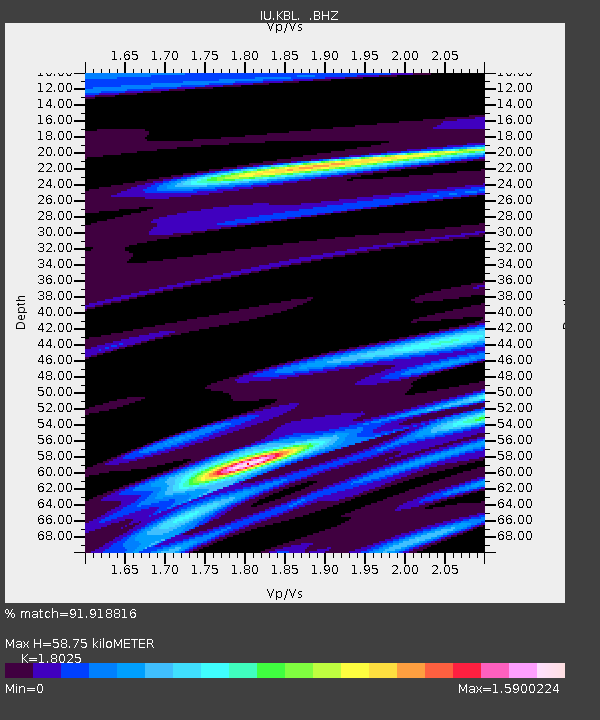
| Estimated Moho Depth: |
58.75 km |
| Estimated Crust Vp/Vs: |
1.80 |
| Assumed Crust Vp: |
6.641 km/s |
| Estimated Crust Vs: |
3.684 km/s |
| Estimated Crust Poisson's Ratio: |
0.28 |
|
| Radial Match: |
91.918816 % |
| Radial Bump: |
400 |
| Transverse Match: |
81.205765 % |
| Transverse Bump: |
400 |
| SOD ConfigId: |
494114 |
| Insert Time: |
2013-05-15 04:57:03.138 +0000 |
| GWidth: |
2.5 |
| Max Bumps: |
400 |
| Tol: |
0.001 |
|
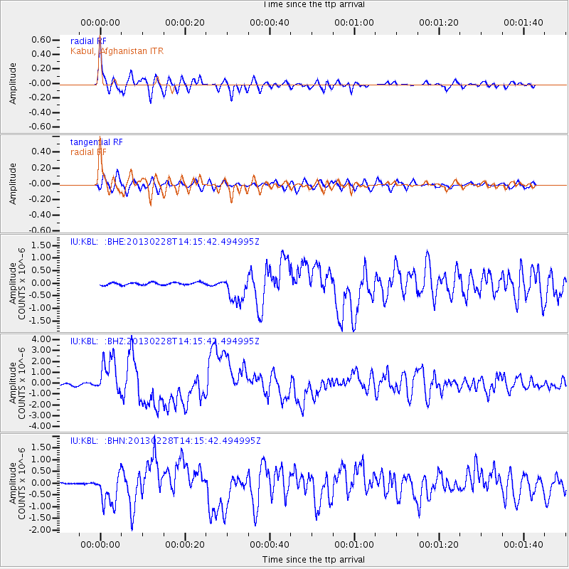
Signal To Noise
| Channel | StoN | STA | LTA |
| IU:KBL: :BHZ:20130228T14:15:42.494995Z | 23.821976 | 1.7054905E-6 | 7.159316E-8 |
| IU:KBL: :BHN:20130228T14:15:42.494995Z | 13.754811 | 7.050237E-7 | 5.1256514E-8 |
| IU:KBL: :BHE:20130228T14:15:42.494995Z | 11.158467 | 5.466733E-7 | 4.8991787E-8 |
| Arrivals |
| Ps | 7.4 SECOND |
| PpPs | 24 SECOND |
| PsPs/PpSs | 31 SECOND |


