You are here: Home > Network List > IW - Intermountain West Stations List
> Station IMW Indian Meadow, Wyoming, USA > Earthquake Result Viewer
IMW Indian Meadow, Wyoming, USA - Earthquake Result Viewer
| Earthquake location: |
Kuril Islands |
| Earthquake latitude/longitude: |
51.0/157.3 |
| Earthquake time(UTC): |
2013/02/28 (059) 14:05:50 GMT |
| Earthquake Depth: |
41 km |
| Earthquake Magnitude: |
6.4 MB, 6.7 MS, 6.9 MW, 6.8 MW |
| Earthquake Catalog/Contributor: |
WHDF/NEIC |
|
| Network: |
IW Intermountain West |
| Station: |
IMW Indian Meadow, Wyoming, USA |
| Lat/Lon: |
43.90 N/110.94 W |
| Elevation: |
2646 m |
|
| Distance: |
58.6 deg |
| Az: |
57.836 deg |
| Baz: |
312.213 deg |
| Ray Param: |
0.06265479 |
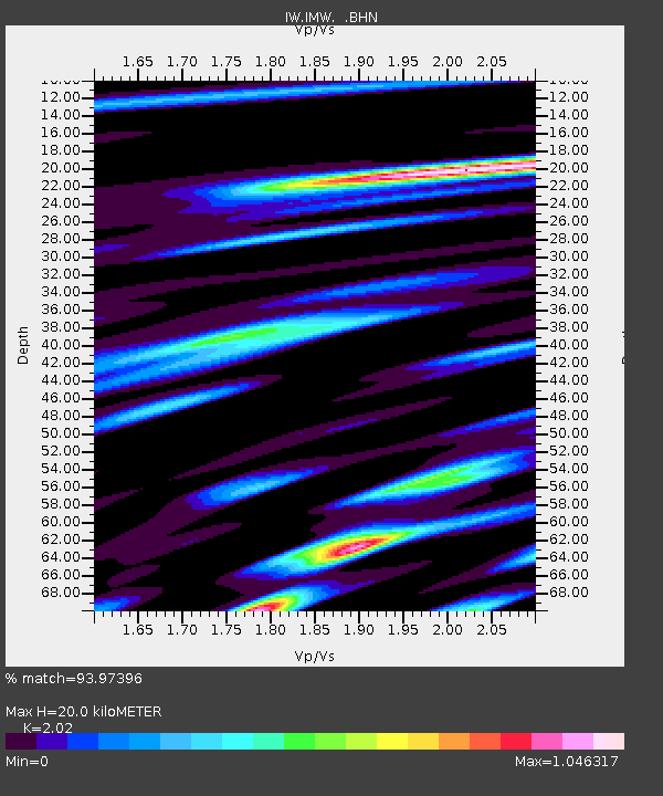
| Estimated Moho Depth: |
20.0 km |
| Estimated Crust Vp/Vs: |
2.02 |
| Assumed Crust Vp: |
6.207 km/s |
| Estimated Crust Vs: |
3.073 km/s |
| Estimated Crust Poisson's Ratio: |
0.34 |
|
| Radial Match: |
93.97396 % |
| Radial Bump: |
400 |
| Transverse Match: |
82.53638 % |
| Transverse Bump: |
400 |
| SOD ConfigId: |
494114 |
| Insert Time: |
2013-05-15 04:57:40.351 +0000 |
| GWidth: |
2.5 |
| Max Bumps: |
400 |
| Tol: |
0.001 |
|
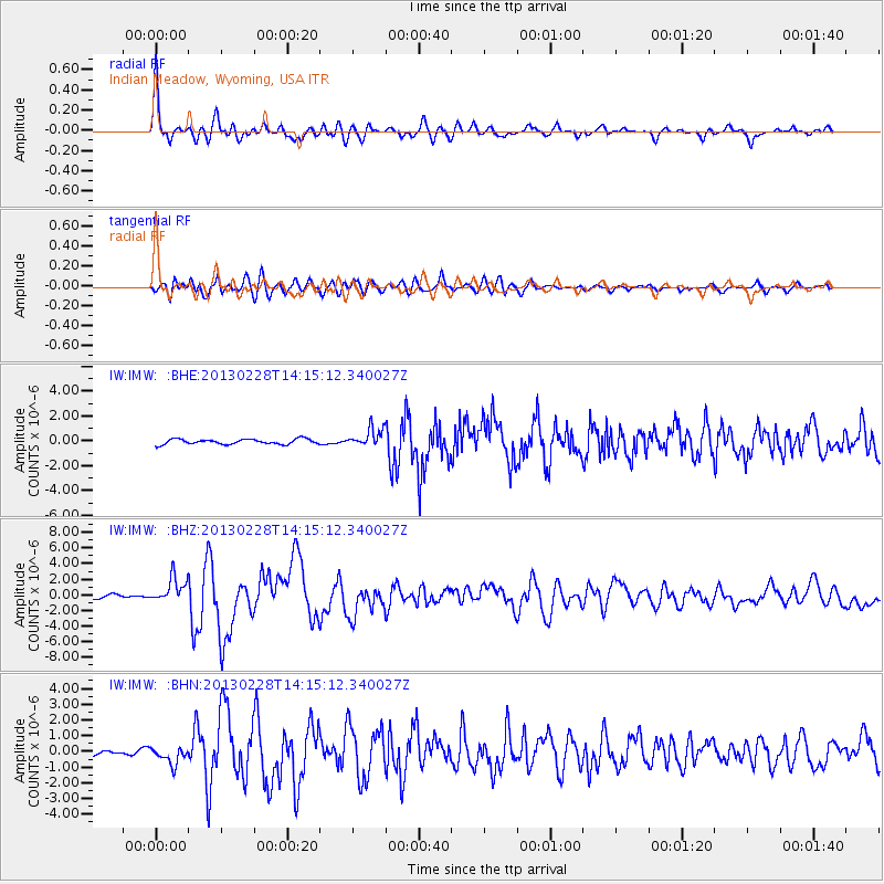
Signal To Noise
| Channel | StoN | STA | LTA |
| IW:IMW: :BHZ:20130228T14:15:12.340027Z | 8.848233 | 1.5839574E-6 | 1.7901398E-7 |
| IW:IMW: :BHN:20130228T14:15:12.340027Z | 2.121521 | 5.354227E-7 | 2.5237682E-7 |
| IW:IMW: :BHE:20130228T14:15:12.340027Z | 3.5008187 | 7.284082E-7 | 2.0806796E-7 |
| Arrivals |
| Ps | 3.4 SECOND |
| PpPs | 9.4 SECOND |
| PsPs/PpSs | 13 SECOND |


