You are here: Home > Network List > GT - Global Telemetered Seismograph Network (USAF/USGS) Stations List
> Station DBIC Dimbokro, Cote d'Ivoire > Earthquake Result Viewer
DBIC Dimbokro, Cote d'Ivoire - Earthquake Result Viewer
| Earthquake location: |
Northern Peru |
| Earthquake latitude/longitude: |
-4.4/-76.7 |
| Earthquake time(UTC): |
1997/10/28 (301) 06:15:17 GMT |
| Earthquake Depth: |
112 km |
| Earthquake Magnitude: |
6.6 MB, 6.3 MS, 7.2 UNKNOWN, 6.6 ME |
| Earthquake Catalog/Contributor: |
WHDF/NEIC |
|
| Network: |
GT Global Telemetered Seismograph Network (USAF/USGS) |
| Station: |
DBIC Dimbokro, Cote d'Ivoire |
| Lat/Lon: |
6.67 N/4.86 W |
| Elevation: |
125 m |
|
| Distance: |
72.5 deg |
| Az: |
81.651 deg |
| Baz: |
263.315 deg |
| Ray Param: |
0.05332718 |
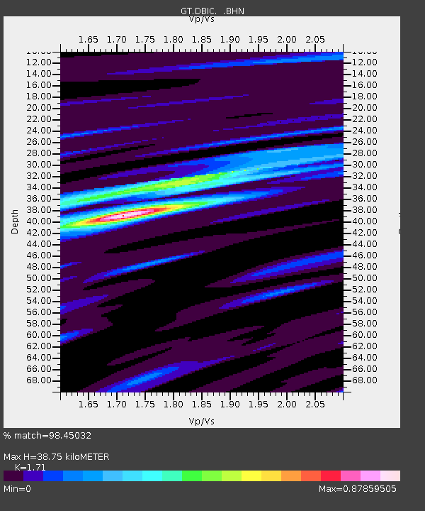
| Estimated Moho Depth: |
38.75 km |
| Estimated Crust Vp/Vs: |
1.71 |
| Assumed Crust Vp: |
6.419 km/s |
| Estimated Crust Vs: |
3.754 km/s |
| Estimated Crust Poisson's Ratio: |
0.24 |
|
| Radial Match: |
98.45032 % |
| Radial Bump: |
303 |
| Transverse Match: |
94.98126 % |
| Transverse Bump: |
400 |
| SOD ConfigId: |
6273 |
| Insert Time: |
2010-02-27 01:54:45.557 +0000 |
| GWidth: |
2.5 |
| Max Bumps: |
400 |
| Tol: |
0.001 |
|
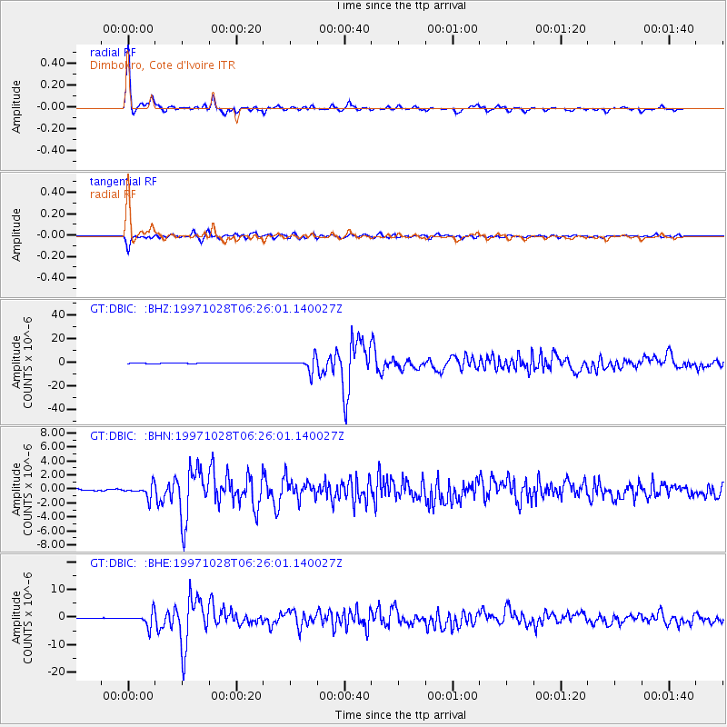
Signal To Noise
| Channel | StoN | STA | LTA |
| GT:DBIC: :BHN:19971028T06:26:01.140027Z | 8.0775795 | 9.1061196E-7 | 1.12733275E-7 |
| GT:DBIC: :BHE:19971028T06:26:01.140027Z | 31.28874 | 2.5022166E-6 | 7.99718E-8 |
| GT:DBIC: :BHZ:19971028T06:26:01.140027Z | 33.70344 | 5.8266073E-6 | 1.7287871E-7 |
| Arrivals |
| Ps | 4.4 SECOND |
| PpPs | 16 SECOND |
| PsPs/PpSs | 20 SECOND |


