You are here: Home > Network List > OE - Austrian Seismic Network Stations List
> Station KBA Koelnbreinsperre, Kaernten, Austria > Earthquake Result Viewer
KBA Koelnbreinsperre, Kaernten, Austria - Earthquake Result Viewer
| Earthquake location: |
Kuril Islands |
| Earthquake latitude/longitude: |
51.0/157.3 |
| Earthquake time(UTC): |
2013/02/28 (059) 14:05:50 GMT |
| Earthquake Depth: |
41 km |
| Earthquake Magnitude: |
6.4 MB, 6.7 MS, 6.9 MW, 6.8 MW |
| Earthquake Catalog/Contributor: |
WHDF/NEIC |
|
| Network: |
OE Austrian Seismic Network |
| Station: |
KBA Koelnbreinsperre, Kaernten, Austria |
| Lat/Lon: |
47.08 N/13.34 E |
| Elevation: |
1721 m |
|
| Distance: |
77.5 deg |
| Az: |
335.667 deg |
| Baz: |
22.416 deg |
| Ray Param: |
0.0501952 |
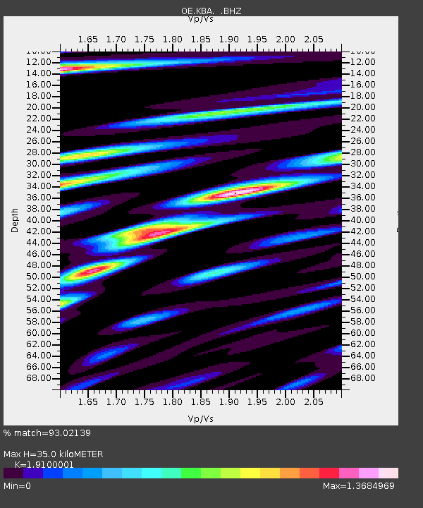
| Estimated Moho Depth: |
35.0 km |
| Estimated Crust Vp/Vs: |
1.91 |
| Assumed Crust Vp: |
6.35 km/s |
| Estimated Crust Vs: |
3.325 km/s |
| Estimated Crust Poisson's Ratio: |
0.31 |
|
| Radial Match: |
93.02139 % |
| Radial Bump: |
400 |
| Transverse Match: |
90.9815 % |
| Transverse Bump: |
400 |
| SOD ConfigId: |
494114 |
| Insert Time: |
2013-05-15 05:03:43.951 +0000 |
| GWidth: |
2.5 |
| Max Bumps: |
400 |
| Tol: |
0.001 |
|

Signal To Noise
| Channel | StoN | STA | LTA |
| OE:KBA: :BHZ:20130228T14:17:10.749023Z | 28.397038 | 3.726668E-6 | 1.312344E-7 |
| OE:KBA: :BHN:20130228T14:17:10.749023Z | 8.226373 | 8.478932E-7 | 1.03070114E-7 |
| OE:KBA: :BHE:20130228T14:17:10.749023Z | 3.544368 | 5.871843E-7 | 1.6566685E-7 |
| Arrivals |
| Ps | 5.2 SECOND |
| PpPs | 16 SECOND |
| PsPs/PpSs | 21 SECOND |


