You are here: Home > Network List > TA - USArray Transportable Network (new EarthScope stations) Stations List
> Station M04C Macdoel, CA, USA > Earthquake Result Viewer
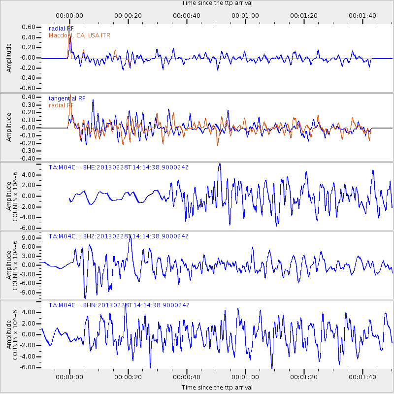
M04C Macdoel, CA, USA - Earthquake Result Viewer
*The percent match for this event was below the threshold and hence no stack was calculated.
| Earthquake location: |
Kuril Islands |
| Earthquake latitude/longitude: |
51.0/157.3 |
| Earthquake time(UTC): |
2013/02/28 (059) 14:05:50 GMT |
| Earthquake Depth: |
41 km |
| Earthquake Magnitude: |
6.4 MB, 6.7 MS, 6.9 MW, 6.8 MW |
| Earthquake Catalog/Contributor: |
WHDF/NEIC |
|
| Network: |
TA USArray Transportable Network (new EarthScope stations) |
| Station: |
M04C Macdoel, CA, USA |
| Lat/Lon: |
41.78 N/121.84 W |
| Elevation: |
1391 m |
|
| Distance: |
53.9 deg |
| Az: |
66.049 deg |
| Baz: |
309.387 deg |
| Ray Param: |
$rayparam |
*The percent match for this event was below the threshold and hence was not used in the summary stack. |
|
| Radial Match: |
76.69404 % |
| Radial Bump: |
400 |
| Transverse Match: |
67.02116 % |
| Transverse Bump: |
400 |
| SOD ConfigId: |
494114 |
| Insert Time: |
2013-05-15 05:05:08.317 +0000 |
| GWidth: |
2.5 |
| Max Bumps: |
400 |
| Tol: |
0.001 |
|
Signal To Noise
| Channel | StoN | STA | LTA |
| TA:M04C: :BHZ:20130228T14:14:38.900024Z | 3.418034 | 2.7391845E-6 | 8.0139176E-7 |
| TA:M04C: :BHN:20130228T14:14:38.900024Z | 0.68141073 | 7.617564E-7 | 1.1179108E-6 |
| TA:M04C: :BHE:20130228T14:14:38.900024Z | 1.4419782 | 1.030569E-6 | 7.146911E-7 |
| Arrivals |
| Ps | |
| PpPs | |
| PsPs/PpSs | |


