You are here: Home > Network List > TA - USArray Transportable Network (new EarthScope stations) Stations List
> Station TPFO Pinon Flats, CA, USA > Earthquake Result Viewer
TPFO Pinon Flats, CA, USA - Earthquake Result Viewer
| Earthquake location: |
Kuril Islands |
| Earthquake latitude/longitude: |
51.0/157.3 |
| Earthquake time(UTC): |
2013/02/28 (059) 14:05:50 GMT |
| Earthquake Depth: |
41 km |
| Earthquake Magnitude: |
6.4 MB, 6.7 MS, 6.9 MW, 6.8 MW |
| Earthquake Catalog/Contributor: |
WHDF/NEIC |
|
| Network: |
TA USArray Transportable Network (new EarthScope stations) |
| Station: |
TPFO Pinon Flats, CA, USA |
| Lat/Lon: |
33.61 N/116.45 W |
| Elevation: |
1275 m |
|
| Distance: |
62.5 deg |
| Az: |
69.806 deg |
| Baz: |
314.661 deg |
| Ray Param: |
0.060079228 |
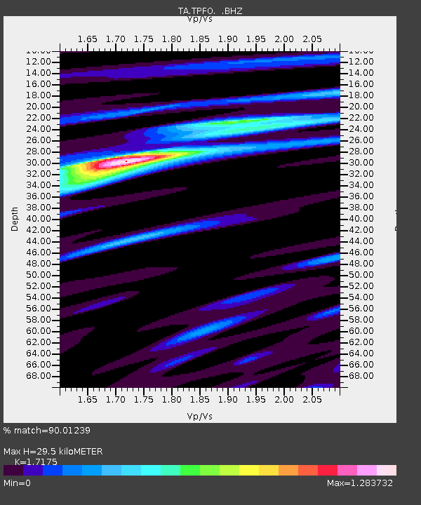
| Estimated Moho Depth: |
29.5 km |
| Estimated Crust Vp/Vs: |
1.72 |
| Assumed Crust Vp: |
6.264 km/s |
| Estimated Crust Vs: |
3.647 km/s |
| Estimated Crust Poisson's Ratio: |
0.24 |
|
| Radial Match: |
90.01239 % |
| Radial Bump: |
338 |
| Transverse Match: |
65.569984 % |
| Transverse Bump: |
326 |
| SOD ConfigId: |
494114 |
| Insert Time: |
2013-05-15 05:08:03.946 +0000 |
| GWidth: |
2.5 |
| Max Bumps: |
400 |
| Tol: |
0.001 |
|
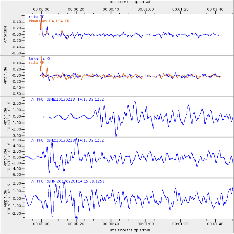
Signal To Noise
| Channel | StoN | STA | LTA |
| TA:TPFO: :BHZ:20130228T14:15:39.125Z | 5.195444 | 2.2963054E-6 | 4.4198444E-7 |
| TA:TPFO: :BHN:20130228T14:15:39.125Z | 1.6383152 | 8.593516E-7 | 5.2453373E-7 |
| TA:TPFO: :BHE:20130228T14:15:39.125Z | 3.7667072 | 7.954172E-7 | 2.1117043E-7 |
| Arrivals |
| Ps | 3.5 SECOND |
| PpPs | 12 SECOND |
| PsPs/PpSs | 16 SECOND |


