You are here: Home > Network List > TA - USArray Transportable Network (new EarthScope stations) Stations List
> Station N54A Moraine State Park, Portersville, PA, USA > Earthquake Result Viewer
N54A Moraine State Park, Portersville, PA, USA - Earthquake Result Viewer
| Earthquake location: |
Kuril Islands |
| Earthquake latitude/longitude: |
51.0/157.3 |
| Earthquake time(UTC): |
2013/02/28 (059) 14:05:50 GMT |
| Earthquake Depth: |
41 km |
| Earthquake Magnitude: |
6.4 MB, 6.7 MS, 6.9 MW, 6.8 MW |
| Earthquake Catalog/Contributor: |
WHDF/NEIC |
|
| Network: |
TA USArray Transportable Network (new EarthScope stations) |
| Station: |
N54A Moraine State Park, Portersville, PA, USA |
| Lat/Lon: |
40.96 N/79.99 W |
| Elevation: |
408 m |
|
| Distance: |
75.7 deg |
| Az: |
41.105 deg |
| Baz: |
326.696 deg |
| Ray Param: |
0.051417634 |
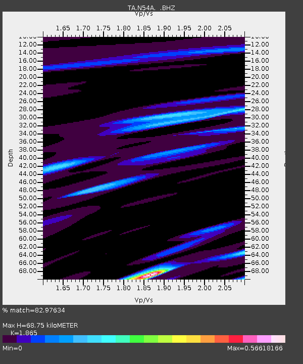
| Estimated Moho Depth: |
68.75 km |
| Estimated Crust Vp/Vs: |
1.87 |
| Assumed Crust Vp: |
6.121 km/s |
| Estimated Crust Vs: |
3.282 km/s |
| Estimated Crust Poisson's Ratio: |
0.30 |
|
| Radial Match: |
82.97634 % |
| Radial Bump: |
400 |
| Transverse Match: |
80.557365 % |
| Transverse Bump: |
400 |
| SOD ConfigId: |
494114 |
| Insert Time: |
2013-05-15 05:09:26.714 +0000 |
| GWidth: |
2.5 |
| Max Bumps: |
400 |
| Tol: |
0.001 |
|
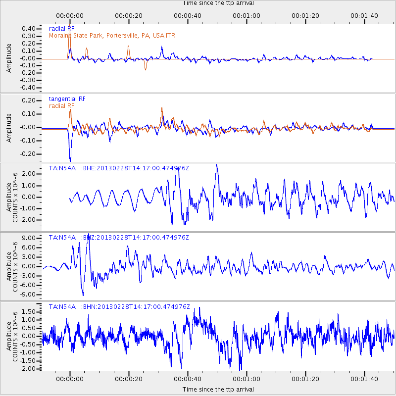
Signal To Noise
| Channel | StoN | STA | LTA |
| TA:N54A: :BHZ:20130228T14:17:00.474976Z | 6.9149747 | 4.4854582E-6 | 6.486586E-7 |
| TA:N54A: :BHN:20130228T14:17:00.474976Z | 1.656031 | 4.856856E-7 | 2.9328288E-7 |
| TA:N54A: :BHE:20130228T14:17:00.474976Z | 2.0106773 | 9.630571E-7 | 4.7897146E-7 |
| Arrivals |
| Ps | 10.0 SECOND |
| PpPs | 31 SECOND |
| PsPs/PpSs | 41 SECOND |


