You are here: Home > Network List > TA - USArray Transportable Network (new EarthScope stations) Stations List
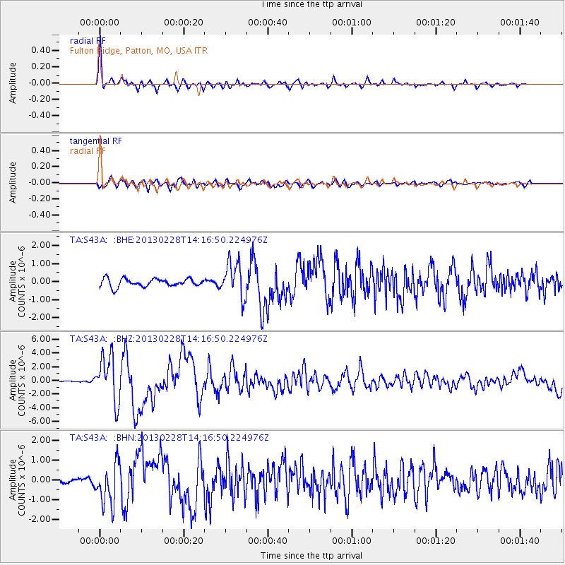
> Station S43A Fulton Ridge, Patton, MO, USA > Earthquake Result Viewer
S43A Fulton Ridge, Patton, MO, USA - Earthquake Result Viewer
| Earthquake location: |
Kuril Islands |
| Earthquake latitude/longitude: |
51.0/157.3 |
| Earthquake time(UTC): |
2013/02/28 (059) 14:05:50 GMT |
| Earthquake Depth: |
41 km |
| Earthquake Magnitude: |
6.4 MB, 6.7 MS, 6.9 MW, 6.8 MW |
| Earthquake Catalog/Contributor: |
WHDF/NEIC |
|
| Network: |
TA USArray Transportable Network (new EarthScope stations) |
| Station: |
S43A Fulton Ridge, Patton, MO, USA |
| Lat/Lon: |
37.57 N/90.08 W |
| Elevation: |
263 m |
|
| Distance: |
73.9 deg |
| Az: |
49.743 deg |
| Baz: |
322.592 deg |
| Ray Param: |
0.0526059 |
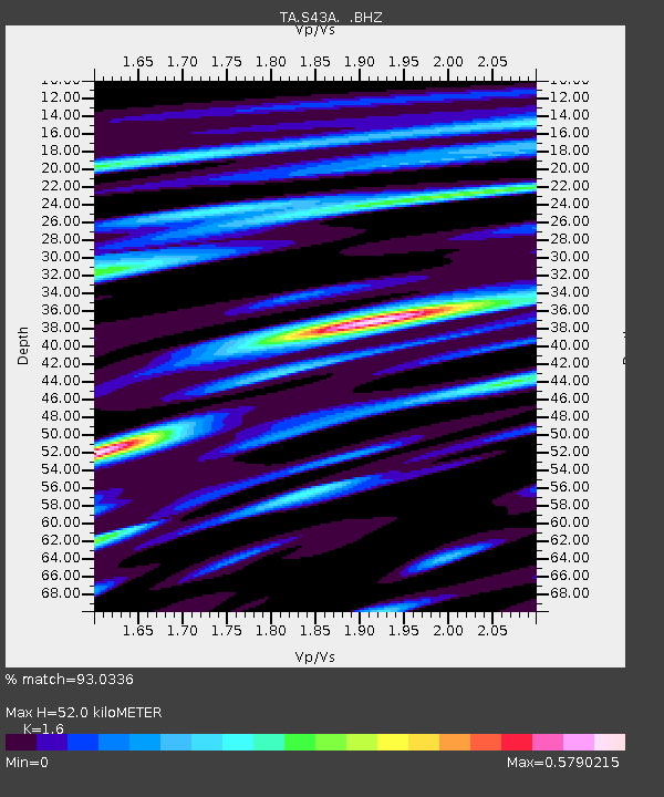
| Estimated Moho Depth: |
52.0 km |
| Estimated Crust Vp/Vs: |
1.60 |
| Assumed Crust Vp: |
6.53 km/s |
| Estimated Crust Vs: |
4.082 km/s |
| Estimated Crust Poisson's Ratio: |
0.18 |
|
| Radial Match: |
93.0336 % |
| Radial Bump: |
368 |
| Transverse Match: |
79.3707 % |
| Transverse Bump: |
400 |
| SOD ConfigId: |
494114 |
| Insert Time: |
2013-05-15 05:11:01.151 +0000 |
| GWidth: |
2.5 |
| Max Bumps: |
400 |
| Tol: |
0.001 |
|
Signal To Noise
| Channel | StoN | STA | LTA |
| TA:S43A: :BHZ:20130228T14:16:50.224976Z | 15.793062 | 3.397802E-6 | 2.1514522E-7 |
| TA:S43A: :BHN:20130228T14:16:50.224976Z | 3.5709364 | 1.0734856E-6 | 3.006174E-7 |
| TA:S43A: :BHE:20130228T14:16:50.224976Z | 4.56211 | 9.985616E-7 | 2.1888152E-7 |
| Arrivals |
| Ps | 5.0 SECOND |
| PpPs | 20 SECOND |
| PsPs/PpSs | 25 SECOND |


