You are here: Home > Network List > TA - USArray Transportable Network (new EarthScope stations) Stations List
> Station K41A Shullsburg, WI, USA > Earthquake Result Viewer
K41A Shullsburg, WI, USA - Earthquake Result Viewer

| Earthquake location: |
Kuril Islands |
| Earthquake latitude/longitude: |
51.0/157.3 |
| Earthquake time(UTC): |
2013/02/28 (059) 14:05:50 GMT |
| Earthquake Depth: |
41 km |
| Earthquake Magnitude: |
6.4 MB, 6.7 MS, 6.9 MW, 6.8 MW |
| Earthquake Catalog/Contributor: |
WHDF/NEIC |
|
| Network: |
TA USArray Transportable Network (new EarthScope stations) |
| Station: |
K41A Shullsburg, WI, USA |
| Lat/Lon: |
42.61 N/90.30 W |
| Elevation: |
298 m |
|
| Distance: |
69.9 deg |
| Az: |
46.634 deg |
| Baz: |
321.477 deg |
| Ray Param: |
0.055296984 |
| Estimated Moho Depth: |
11.75 km |
| Estimated Crust Vp/Vs: |
1.88 |
| Assumed Crust Vp: |
6.53 km/s |
| Estimated Crust Vs: |
3.464 km/s |
| Estimated Crust Poisson's Ratio: |
0.30 |
|
| Radial Match: |
92.547295 % |
| Radial Bump: |
400 |
| Transverse Match: |
77.23614 % |
| Transverse Bump: |
400 |
| SOD ConfigId: |
494114 |
| Insert Time: |
2013-05-15 05:12:32.202 +0000 |
| GWidth: |
2.5 |
| Max Bumps: |
400 |
| Tol: |
0.001 |
|
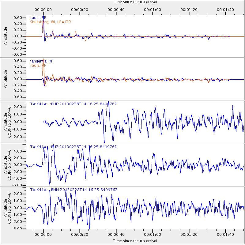
Signal To Noise
| Channel | StoN | STA | LTA |
| TA:K41A: :BHZ:20130228T14:16:25.849976Z | 7.511787 | 3.331478E-6 | 4.4350006E-7 |
| TA:K41A: :BHN:20130228T14:16:25.849976Z | 5.654845 | 1.4802221E-6 | 2.6176176E-7 |
| TA:K41A: :BHE:20130228T14:16:25.849976Z | 4.3801436 | 1.2349113E-6 | 2.8193398E-7 |
| Arrivals |
| Ps | 1.7 SECOND |
| PpPs | 5.0 SECOND |
| PsPs/PpSs | 6.7 SECOND |


