You are here: Home > Network List > TA - USArray Transportable Network (new EarthScope stations) Stations List
> Station V43A Jonesboro, AR, USA > Earthquake Result Viewer
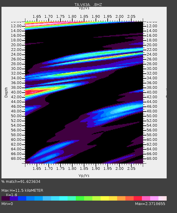
V43A Jonesboro, AR, USA - Earthquake Result Viewer
| Earthquake location: |
Kuril Islands |
| Earthquake latitude/longitude: |
51.0/157.3 |
| Earthquake time(UTC): |
2013/02/28 (059) 14:05:50 GMT |
| Earthquake Depth: |
41 km |
| Earthquake Magnitude: |
6.4 MB, 6.7 MS, 6.9 MW, 6.8 MW |
| Earthquake Catalog/Contributor: |
WHDF/NEIC |
|
| Network: |
TA USArray Transportable Network (new EarthScope stations) |
| Station: |
V43A Jonesboro, AR, USA |
| Lat/Lon: |
35.79 N/90.54 W |
| Elevation: |
74 m |
|
| Distance: |
75.1 deg |
| Az: |
51.176 deg |
| Baz: |
322.695 deg |
| Ray Param: |
0.051815234 |
| Estimated Moho Depth: |
11.5 km |
| Estimated Crust Vp/Vs: |
1.60 |
| Assumed Crust Vp: |
6.273 km/s |
| Estimated Crust Vs: |
3.921 km/s |
| Estimated Crust Poisson's Ratio: |
0.18 |
|
| Radial Match: |
91.623634 % |
| Radial Bump: |
400 |
| Transverse Match: |
67.12048 % |
| Transverse Bump: |
400 |
| SOD ConfigId: |
494114 |
| Insert Time: |
2013-05-15 05:12:52.372 +0000 |
| GWidth: |
2.5 |
| Max Bumps: |
400 |
| Tol: |
0.001 |
|

Signal To Noise
| Channel | StoN | STA | LTA |
| TA:V43A: :BHZ:20130228T14:16:57.099976Z | 5.797837 | 3.918771E-6 | 6.7590224E-7 |
| TA:V43A: :BHN:20130228T14:16:57.099976Z | 1.957952 | 2.2138586E-6 | 1.1307012E-6 |
| TA:V43A: :BHE:20130228T14:16:57.099976Z | 1.4156381 | 1.801455E-6 | 1.2725393E-6 |
| Arrivals |
| Ps | 1.1 SECOND |
| PpPs | 4.6 SECOND |
| PsPs/PpSs | 5.7 SECOND |


