You are here: Home > Network List > US - United States National Seismic Network Stations List
> Station MSO Missoula, Montana, USA > Earthquake Result Viewer
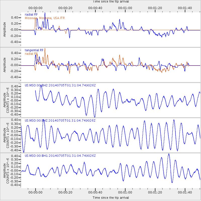
MSO Missoula, Montana, USA - Earthquake Result Viewer
*The percent match for this event was below the threshold and hence no stack was calculated.
| Earthquake location: |
Kermadec Islands, New Zealand |
| Earthquake latitude/longitude: |
-30.4/-177.9 |
| Earthquake time(UTC): |
2014/07/05 (186) 01:18:08 GMT |
| Earthquake Depth: |
10 km |
| Earthquake Magnitude: |
5.2 MW, 5.0 mb |
| Earthquake Catalog/Contributor: |
ISC/ISC |
|
| Network: |
US United States National Seismic Network |
| Station: |
MSO Missoula, Montana, USA |
| Lat/Lon: |
46.83 N/113.94 W |
| Elevation: |
1264 m |
|
| Distance: |
96.1 deg |
| Az: |
38.364 deg |
| Baz: |
231.347 deg |
| Ray Param: |
$rayparam |
*The percent match for this event was below the threshold and hence was not used in the summary stack. |
|
| Radial Match: |
60.504967 % |
| Radial Bump: |
400 |
| Transverse Match: |
64.61195 % |
| Transverse Bump: |
400 |
| SOD ConfigId: |
3390531 |
| Insert Time: |
2019-04-12 17:12:22.734 +0000 |
| GWidth: |
2.5 |
| Max Bumps: |
400 |
| Tol: |
0.001 |
|
Signal To Noise
| Channel | StoN | STA | LTA |
| US:MSO:00:BHZ:20140705T01:31:04.749026Z | 0.8892466 | 1.768661E-7 | 1.9889431E-7 |
| US:MSO:00:BH1:20140705T01:31:04.749026Z | 1.6238557 | 1.5073586E-7 | 9.282589E-8 |
| US:MSO:00:BH2:20140705T01:31:04.749026Z | 2.0177166 | 2.6921865E-7 | 1.3342738E-7 |
| Arrivals |
| Ps | |
| PpPs | |
| PsPs/PpSs | |


