You are here: Home > Network List > TA - USArray Transportable Network (new EarthScope stations) Stations List
> Station W42A Bald Knob, AR, USA > Earthquake Result Viewer
W42A Bald Knob, AR, USA - Earthquake Result Viewer
| Earthquake location: |
Kuril Islands |
| Earthquake latitude/longitude: |
51.0/157.3 |
| Earthquake time(UTC): |
2013/02/28 (059) 14:05:50 GMT |
| Earthquake Depth: |
41 km |
| Earthquake Magnitude: |
6.4 MB, 6.7 MS, 6.9 MW, 6.8 MW |
| Earthquake Catalog/Contributor: |
WHDF/NEIC |
|
| Network: |
TA USArray Transportable Network (new EarthScope stations) |
| Station: |
W42A Bald Knob, AR, USA |
| Lat/Lon: |
35.27 N/91.52 W |
| Elevation: |
71 m |
|
| Distance: |
75.0 deg |
| Az: |
52.153 deg |
| Baz: |
322.381 deg |
| Ray Param: |
0.051866442 |
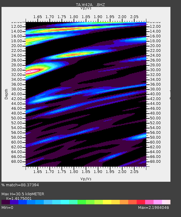
| Estimated Moho Depth: |
30.5 km |
| Estimated Crust Vp/Vs: |
1.62 |
| Assumed Crust Vp: |
6.273 km/s |
| Estimated Crust Vs: |
3.878 km/s |
| Estimated Crust Poisson's Ratio: |
0.19 |
|
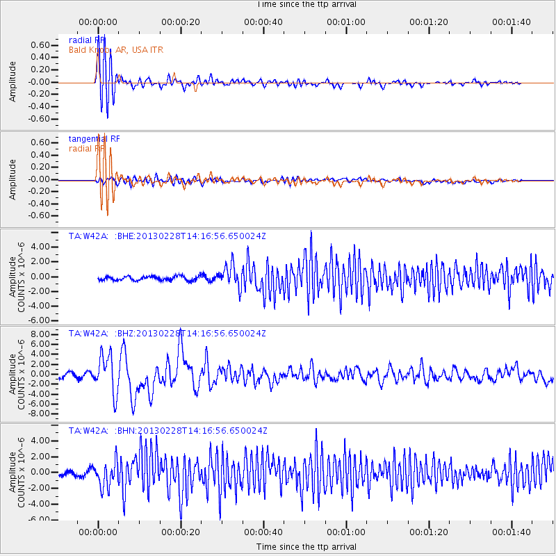
| Radial Match: |
88.37394 % |
| Radial Bump: |
400 |
| Transverse Match: |
72.18865 % |
| Transverse Bump: |
400 |
| SOD ConfigId: |
494114 |
| Insert Time: |
2013-05-15 05:13:29.996 +0000 |
| GWidth: |
2.5 |
| Max Bumps: |
400 |
| Tol: |
0.001 |
|
Signal To Noise
| Channel | StoN | STA | LTA |
| TA:W42A: :BHZ:20130228T14:16:56.650024Z | 8.838295 | 3.9021243E-6 | 4.415019E-7 |
| TA:W42A: :BHN:20130228T14:16:56.650024Z | 4.575436 | 1.622509E-6 | 3.5461298E-7 |
| TA:W42A: :BHE:20130228T14:16:56.650024Z | 5.3721805 | 1.5058822E-6 | 2.8031118E-7 |
| Arrivals |
| Ps | 3.1 SECOND |
| PpPs | 12 SECOND |
| PsPs/PpSs | 15 SECOND |


