You are here: Home > Network List > TA - USArray Transportable Network (new EarthScope stations) Stations List
> Station M42A Sheffield, IL, USA > Earthquake Result Viewer
M42A Sheffield, IL, USA - Earthquake Result Viewer
| Earthquake location: |
Kuril Islands |
| Earthquake latitude/longitude: |
51.0/157.3 |
| Earthquake time(UTC): |
2013/02/28 (059) 14:05:50 GMT |
| Earthquake Depth: |
41 km |
| Earthquake Magnitude: |
6.4 MB, 6.7 MS, 6.9 MW, 6.8 MW |
| Earthquake Catalog/Contributor: |
WHDF/NEIC |
|
| Network: |
TA USArray Transportable Network (new EarthScope stations) |
| Station: |
M42A Sheffield, IL, USA |
| Lat/Lon: |
41.45 N/89.76 W |
| Elevation: |
212 m |
|
| Distance: |
71.0 deg |
| Az: |
47.052 deg |
| Baz: |
321.982 deg |
| Ray Param: |
0.05453138 |
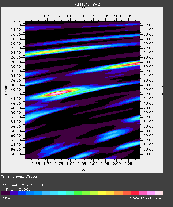
| Estimated Moho Depth: |
41.25 km |
| Estimated Crust Vp/Vs: |
1.74 |
| Assumed Crust Vp: |
6.498 km/s |
| Estimated Crust Vs: |
3.729 km/s |
| Estimated Crust Poisson's Ratio: |
0.25 |
|
| Radial Match: |
81.35103 % |
| Radial Bump: |
400 |
| Transverse Match: |
71.47104 % |
| Transverse Bump: |
400 |
| SOD ConfigId: |
494114 |
| Insert Time: |
2013-05-15 05:13:37.411 +0000 |
| GWidth: |
2.5 |
| Max Bumps: |
400 |
| Tol: |
0.001 |
|
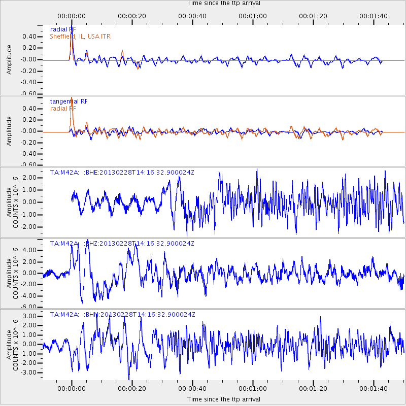
Signal To Noise
| Channel | StoN | STA | LTA |
| TA:M42A: :BHZ:20130228T14:16:32.900024Z | 7.3431234 | 3.2157477E-6 | 4.3792642E-7 |
| TA:M42A: :BHN:20130228T14:16:32.900024Z | 3.2058692 | 1.4913592E-6 | 4.651965E-7 |
| TA:M42A: :BHE:20130228T14:16:32.900024Z | 2.2403498 | 1.0813482E-6 | 4.826693E-7 |
| Arrivals |
| Ps | 4.9 SECOND |
| PpPs | 17 SECOND |
| PsPs/PpSs | 22 SECOND |


