You are here: Home > Network List > TA - USArray Transportable Network (new EarthScope stations) Stations List
> Station U45A Rockin P Farm, Martin, TN, USA > Earthquake Result Viewer
U45A Rockin P Farm, Martin, TN, USA - Earthquake Result Viewer
| Earthquake location: |
Kuril Islands |
| Earthquake latitude/longitude: |
51.0/157.3 |
| Earthquake time(UTC): |
2013/02/28 (059) 14:05:50 GMT |
| Earthquake Depth: |
41 km |
| Earthquake Magnitude: |
6.4 MB, 6.7 MS, 6.9 MW, 6.8 MW |
| Earthquake Catalog/Contributor: |
WHDF/NEIC |
|
| Network: |
TA USArray Transportable Network (new EarthScope stations) |
| Station: |
U45A Rockin P Farm, Martin, TN, USA |
| Lat/Lon: |
36.35 N/88.76 W |
| Elevation: |
144 m |
|
| Distance: |
75.5 deg |
| Az: |
49.636 deg |
| Baz: |
323.349 deg |
| Ray Param: |
0.051533893 |
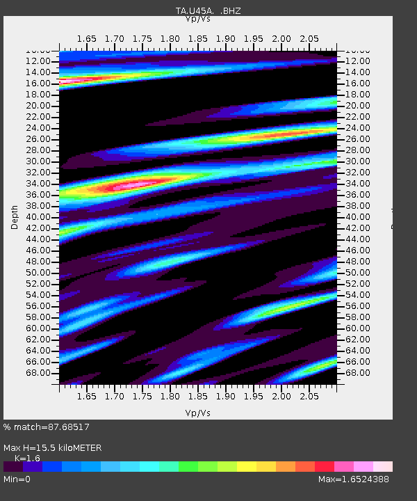
| Estimated Moho Depth: |
15.5 km |
| Estimated Crust Vp/Vs: |
1.60 |
| Assumed Crust Vp: |
6.444 km/s |
| Estimated Crust Vs: |
4.027 km/s |
| Estimated Crust Poisson's Ratio: |
0.18 |
|
| Radial Match: |
87.68517 % |
| Radial Bump: |
400 |
| Transverse Match: |
74.068 % |
| Transverse Bump: |
400 |
| SOD ConfigId: |
494114 |
| Insert Time: |
2013-05-15 05:14:17.231 +0000 |
| GWidth: |
2.5 |
| Max Bumps: |
400 |
| Tol: |
0.001 |
|

Signal To Noise
| Channel | StoN | STA | LTA |
| TA:U45A: :BHZ:20130228T14:16:59.500Z | 11.432838 | 4.0880936E-6 | 3.575747E-7 |
| TA:U45A: :BHN:20130228T14:16:59.500Z | 2.219008 | 1.7848026E-6 | 8.043246E-7 |
| TA:U45A: :BHE:20130228T14:16:59.500Z | 1.7301533 | 1.0967279E-6 | 6.338906E-7 |
| Arrivals |
| Ps | 1.5 SECOND |
| PpPs | 6.0 SECOND |
| PsPs/PpSs | 7.5 SECOND |


