You are here: Home > Network List > TA - USArray Transportable Network (new EarthScope stations) Stations List
> Station G38A Ridgeland, WI, USA > Earthquake Result Viewer
G38A Ridgeland, WI, USA - Earthquake Result Viewer

| Earthquake location: |
Kuril Islands |
| Earthquake latitude/longitude: |
51.0/157.3 |
| Earthquake time(UTC): |
2013/02/28 (059) 14:05:50 GMT |
| Earthquake Depth: |
41 km |
| Earthquake Magnitude: |
6.4 MB, 6.7 MS, 6.9 MW, 6.8 MW |
| Earthquake Catalog/Contributor: |
WHDF/NEIC |
|
| Network: |
TA USArray Transportable Network (new EarthScope stations) |
| Station: |
G38A Ridgeland, WI, USA |
| Lat/Lon: |
45.17 N/91.85 W |
| Elevation: |
370 m |
|
| Distance: |
67.2 deg |
| Az: |
45.828 deg |
| Baz: |
320.111 deg |
| Ray Param: |
0.057062466 |
| Estimated Moho Depth: |
44.25 km |
| Estimated Crust Vp/Vs: |
1.70 |
| Assumed Crust Vp: |
6.571 km/s |
| Estimated Crust Vs: |
3.876 km/s |
| Estimated Crust Poisson's Ratio: |
0.23 |
|
| Radial Match: |
89.05462 % |
| Radial Bump: |
400 |
| Transverse Match: |
72.08127 % |
| Transverse Bump: |
400 |
| SOD ConfigId: |
494114 |
| Insert Time: |
2013-05-15 05:14:58.768 +0000 |
| GWidth: |
2.5 |
| Max Bumps: |
400 |
| Tol: |
0.001 |
|
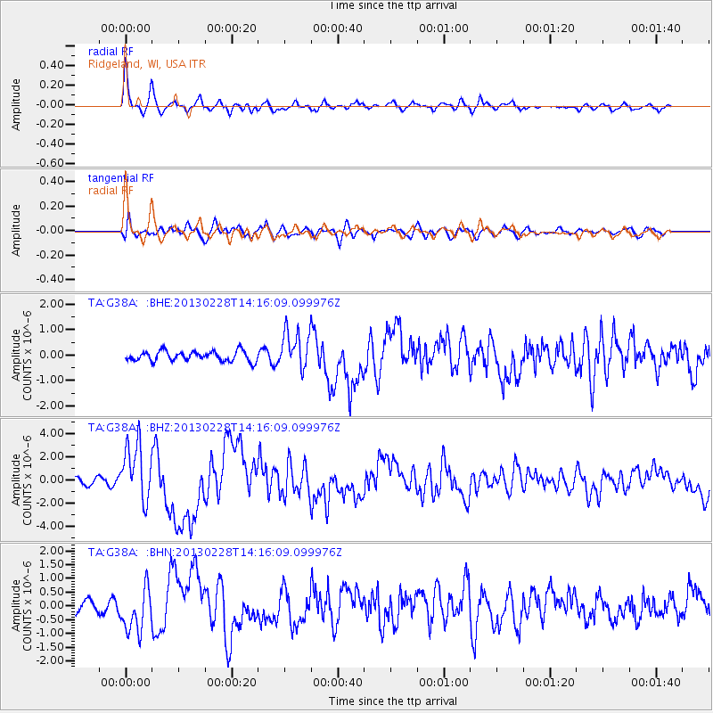
Signal To Noise
| Channel | StoN | STA | LTA |
| TA:G38A: :BHZ:20130228T14:16:09.099976Z | 10.265128 | 2.4873084E-6 | 2.423066E-7 |
| TA:G38A: :BHN:20130228T14:16:09.099976Z | 3.1311052 | 8.0080594E-7 | 2.5575824E-7 |
| TA:G38A: :BHE:20130228T14:16:09.099976Z | 3.8393645 | 7.555962E-7 | 1.9680242E-7 |
| Arrivals |
| Ps | 4.9 SECOND |
| PpPs | 17 SECOND |
| PsPs/PpSs | 22 SECOND |


