You are here: Home > Network List > TA - USArray Transportable Network (new EarthScope stations) Stations List
> Station G39A Holcombe, WI, USA > Earthquake Result Viewer
G39A Holcombe, WI, USA - Earthquake Result Viewer
| Earthquake location: |
Kuril Islands |
| Earthquake latitude/longitude: |
51.0/157.3 |
| Earthquake time(UTC): |
2013/02/28 (059) 14:05:50 GMT |
| Earthquake Depth: |
41 km |
| Earthquake Magnitude: |
6.4 MB, 6.7 MS, 6.9 MW, 6.8 MW |
| Earthquake Catalog/Contributor: |
WHDF/NEIC |
|
| Network: |
TA USArray Transportable Network (new EarthScope stations) |
| Station: |
G39A Holcombe, WI, USA |
| Lat/Lon: |
45.29 N/91.17 W |
| Elevation: |
350 m |
|
| Distance: |
67.4 deg |
| Az: |
45.343 deg |
| Baz: |
320.408 deg |
| Ray Param: |
0.05691978 |
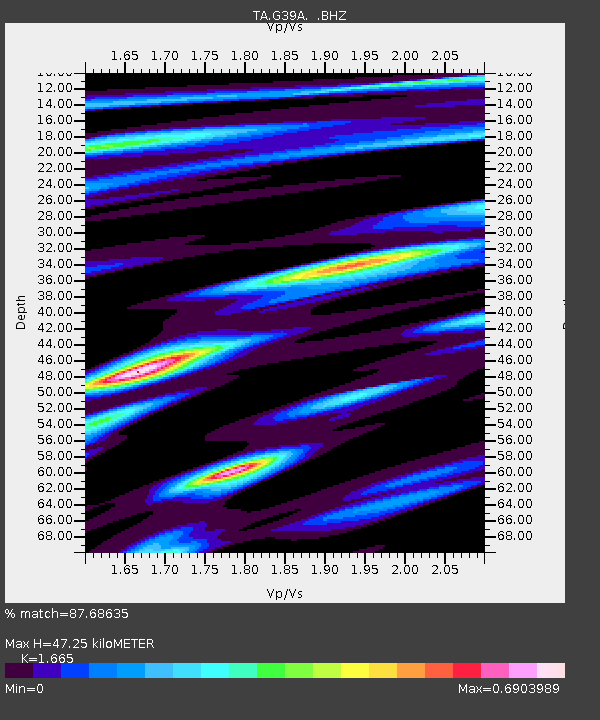
| Estimated Moho Depth: |
47.25 km |
| Estimated Crust Vp/Vs: |
1.66 |
| Assumed Crust Vp: |
6.571 km/s |
| Estimated Crust Vs: |
3.946 km/s |
| Estimated Crust Poisson's Ratio: |
0.22 |
|
| Radial Match: |
87.68635 % |
| Radial Bump: |
331 |
| Transverse Match: |
66.55721 % |
| Transverse Bump: |
400 |
| SOD ConfigId: |
494114 |
| Insert Time: |
2013-05-15 05:15:02.702 +0000 |
| GWidth: |
2.5 |
| Max Bumps: |
400 |
| Tol: |
0.001 |
|

Signal To Noise
| Channel | StoN | STA | LTA |
| TA:G39A: :BHZ:20130228T14:16:10.500Z | 7.3252077 | 2.5523498E-6 | 3.484338E-7 |
| TA:G39A: :BHN:20130228T14:16:10.500Z | 3.6352837 | 1.1028517E-6 | 3.033743E-7 |
| TA:G39A: :BHE:20130228T14:16:10.500Z | 2.6990204 | 9.199518E-7 | 3.4084655E-7 |
| Arrivals |
| Ps | 5.0 SECOND |
| PpPs | 18 SECOND |
| PsPs/PpSs | 23 SECOND |


