You are here: Home > Network List > TA - USArray Transportable Network (new EarthScope stations) Stations List
> Station P43A Skaggs, Pawnee, IL, USA > Earthquake Result Viewer
P43A Skaggs, Pawnee, IL, USA - Earthquake Result Viewer
| Earthquake location: |
Kuril Islands |
| Earthquake latitude/longitude: |
51.0/157.3 |
| Earthquake time(UTC): |
2013/02/28 (059) 14:05:50 GMT |
| Earthquake Depth: |
41 km |
| Earthquake Magnitude: |
6.4 MB, 6.7 MS, 6.9 MW, 6.8 MW |
| Earthquake Catalog/Contributor: |
WHDF/NEIC |
|
| Network: |
TA USArray Transportable Network (new EarthScope stations) |
| Station: |
P43A Skaggs, Pawnee, IL, USA |
| Lat/Lon: |
39.64 N/89.52 W |
| Elevation: |
176 m |
|
| Distance: |
72.6 deg |
| Az: |
48.07 deg |
| Baz: |
322.454 deg |
| Ray Param: |
0.05351499 |
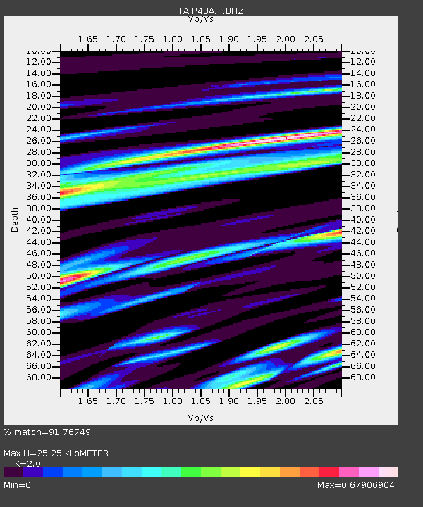
| Estimated Moho Depth: |
25.25 km |
| Estimated Crust Vp/Vs: |
2.00 |
| Assumed Crust Vp: |
6.444 km/s |
| Estimated Crust Vs: |
3.222 km/s |
| Estimated Crust Poisson's Ratio: |
0.33 |
|
| Radial Match: |
91.76749 % |
| Radial Bump: |
399 |
| Transverse Match: |
83.65374 % |
| Transverse Bump: |
400 |
| SOD ConfigId: |
494114 |
| Insert Time: |
2013-05-15 05:15:10.181 +0000 |
| GWidth: |
2.5 |
| Max Bumps: |
400 |
| Tol: |
0.001 |
|

Signal To Noise
| Channel | StoN | STA | LTA |
| TA:P43A: :BHZ:20130228T14:16:42.125Z | 9.009431 | 3.3844028E-6 | 3.7565113E-7 |
| TA:P43A: :BHN:20130228T14:16:42.125Z | 5.1303725 | 1.4676988E-6 | 2.8608036E-7 |
| TA:P43A: :BHE:20130228T14:16:42.125Z | 5.0815644 | 1.0109015E-6 | 1.989351E-7 |
| Arrivals |
| Ps | 4.0 SECOND |
| PpPs | 11 SECOND |
| PsPs/PpSs | 15 SECOND |


