You are here: Home > Network List > TA - USArray Transportable Network (new EarthScope stations) Stations List
> Station F39A Loretta, WI, USA > Earthquake Result Viewer
F39A Loretta, WI, USA - Earthquake Result Viewer
| Earthquake location: |
Kuril Islands |
| Earthquake latitude/longitude: |
51.0/157.3 |
| Earthquake time(UTC): |
2013/02/28 (059) 14:05:50 GMT |
| Earthquake Depth: |
41 km |
| Earthquake Magnitude: |
6.4 MB, 6.7 MS, 6.9 MW, 6.8 MW |
| Earthquake Catalog/Contributor: |
WHDF/NEIC |
|
| Network: |
TA USArray Transportable Network (new EarthScope stations) |
| Station: |
F39A Loretta, WI, USA |
| Lat/Lon: |
45.92 N/90.92 W |
| Elevation: |
440 m |
|
| Distance: |
67.0 deg |
| Az: |
44.761 deg |
| Baz: |
320.361 deg |
| Ray Param: |
0.057161905 |
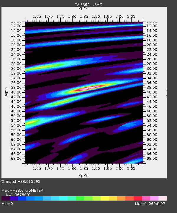
| Estimated Moho Depth: |
38.0 km |
| Estimated Crust Vp/Vs: |
1.87 |
| Assumed Crust Vp: |
6.571 km/s |
| Estimated Crust Vs: |
3.518 km/s |
| Estimated Crust Poisson's Ratio: |
0.30 |
|
| Radial Match: |
88.915695 % |
| Radial Bump: |
400 |
| Transverse Match: |
70.39177 % |
| Transverse Bump: |
400 |
| SOD ConfigId: |
494114 |
| Insert Time: |
2013-05-15 05:16:12.820 +0000 |
| GWidth: |
2.5 |
| Max Bumps: |
400 |
| Tol: |
0.001 |
|
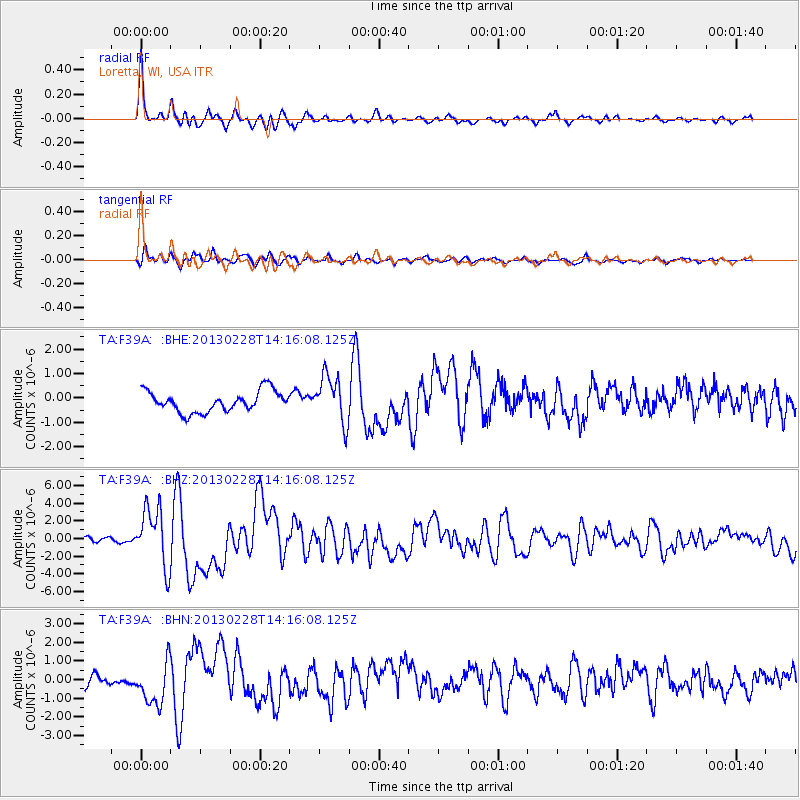
Signal To Noise
| Channel | StoN | STA | LTA |
| TA:F39A: :BHZ:20130228T14:16:08.125Z | 9.710007 | 3.2825417E-6 | 3.3805762E-7 |
| TA:F39A: :BHN:20130228T14:16:08.125Z | 2.3857267 | 1.1339814E-6 | 4.753191E-7 |
| TA:F39A: :BHE:20130228T14:16:08.125Z | 2.262616 | 9.645103E-7 | 4.2628105E-7 |
| Arrivals |
| Ps | 5.2 SECOND |
| PpPs | 16 SECOND |
| PsPs/PpSs | 21 SECOND |


