You are here: Home > Network List > TA - USArray Transportable Network (new EarthScope stations) Stations List
> Station F44A Big Bay de Noc Black Bears, Cooks, MI, USA > Earthquake Result Viewer
F44A Big Bay de Noc Black Bears, Cooks, MI, USA - Earthquake Result Viewer
| Earthquake location: |
Kuril Islands |
| Earthquake latitude/longitude: |
51.0/157.3 |
| Earthquake time(UTC): |
2013/02/28 (059) 14:05:50 GMT |
| Earthquake Depth: |
41 km |
| Earthquake Magnitude: |
6.4 MB, 6.7 MS, 6.9 MW, 6.8 MW |
| Earthquake Catalog/Contributor: |
WHDF/NEIC |
|
| Network: |
TA USArray Transportable Network (new EarthScope stations) |
| Station: |
F44A Big Bay de Noc Black Bears, Cooks, MI, USA |
| Lat/Lon: |
45.97 N/86.42 W |
| Elevation: |
234 m |
|
| Distance: |
68.9 deg |
| Az: |
42.074 deg |
| Baz: |
322.574 deg |
| Ray Param: |
0.05591732 |
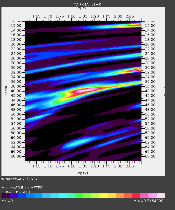
| Estimated Moho Depth: |
39.5 km |
| Estimated Crust Vp/Vs: |
1.86 |
| Assumed Crust Vp: |
6.53 km/s |
| Estimated Crust Vs: |
3.516 km/s |
| Estimated Crust Poisson's Ratio: |
0.30 |
|
| Radial Match: |
87.77634 % |
| Radial Bump: |
328 |
| Transverse Match: |
66.772545 % |
| Transverse Bump: |
400 |
| SOD ConfigId: |
494114 |
| Insert Time: |
2013-05-15 05:16:59.320 +0000 |
| GWidth: |
2.5 |
| Max Bumps: |
400 |
| Tol: |
0.001 |
|
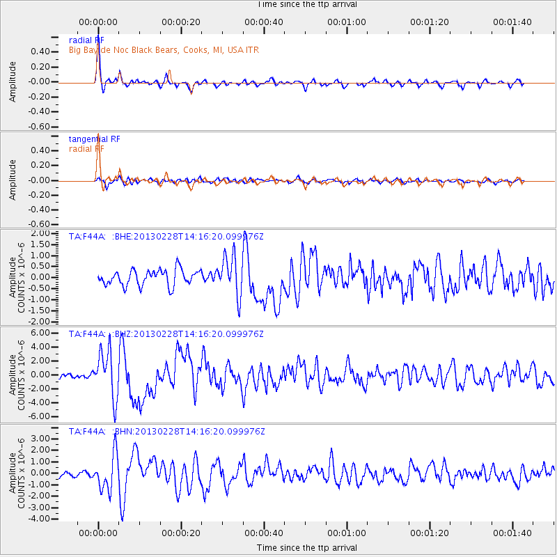
Signal To Noise
| Channel | StoN | STA | LTA |
| TA:F44A: :BHZ:20130228T14:16:20.099976Z | 11.655584 | 3.4408788E-6 | 2.9521289E-7 |
| TA:F44A: :BHN:20130228T14:16:20.099976Z | 3.7077382 | 1.5868443E-6 | 4.2798175E-7 |
| TA:F44A: :BHE:20130228T14:16:20.099976Z | 2.5692115 | 9.0779827E-7 | 3.533373E-7 |
| Arrivals |
| Ps | 5.4 SECOND |
| PpPs | 17 SECOND |
| PsPs/PpSs | 22 SECOND |


