You are here: Home > Network List > TA - USArray Transportable Network (new EarthScope stations) Stations List
> Station H42A Shiocton, WI, USA > Earthquake Result Viewer
H42A Shiocton, WI, USA - Earthquake Result Viewer
| Earthquake location: |
Kuril Islands |
| Earthquake latitude/longitude: |
51.0/157.3 |
| Earthquake time(UTC): |
2013/02/28 (059) 14:05:50 GMT |
| Earthquake Depth: |
41 km |
| Earthquake Magnitude: |
6.4 MB, 6.7 MS, 6.9 MW, 6.8 MW |
| Earthquake Catalog/Contributor: |
WHDF/NEIC |
|
| Network: |
TA USArray Transportable Network (new EarthScope stations) |
| Station: |
H42A Shiocton, WI, USA |
| Lat/Lon: |
44.51 N/88.53 W |
| Elevation: |
244 m |
|
| Distance: |
69.2 deg |
| Az: |
44.296 deg |
| Baz: |
321.877 deg |
| Ray Param: |
0.05575658 |
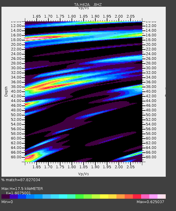
| Estimated Moho Depth: |
17.5 km |
| Estimated Crust Vp/Vs: |
1.61 |
| Assumed Crust Vp: |
6.41 km/s |
| Estimated Crust Vs: |
3.988 km/s |
| Estimated Crust Poisson's Ratio: |
0.18 |
|
| Radial Match: |
87.827034 % |
| Radial Bump: |
400 |
| Transverse Match: |
61.285637 % |
| Transverse Bump: |
400 |
| SOD ConfigId: |
494114 |
| Insert Time: |
2013-05-15 05:17:22.843 +0000 |
| GWidth: |
2.5 |
| Max Bumps: |
400 |
| Tol: |
0.001 |
|

Signal To Noise
| Channel | StoN | STA | LTA |
| TA:H42A: :BHZ:20130228T14:16:21.599976Z | 6.1772795 | 3.0208712E-6 | 4.890294E-7 |
| TA:H42A: :BHN:20130228T14:16:21.599976Z | 1.7076842 | 1.0045591E-6 | 5.882581E-7 |
| TA:H42A: :BHE:20130228T14:16:21.599976Z | 1.950032 | 9.620276E-7 | 4.933394E-7 |
| Arrivals |
| Ps | 1.7 SECOND |
| PpPs | 6.8 SECOND |
| PsPs/PpSs | 8.6 SECOND |


