You are here: Home > Network List > TA - USArray Transportable Network (new EarthScope stations) Stations List
> Station M45A Boilermakers Shaker, Crown Point, IN, USA > Earthquake Result Viewer
M45A Boilermakers Shaker, Crown Point, IN, USA - Earthquake Result Viewer
| Earthquake location: |
Kuril Islands |
| Earthquake latitude/longitude: |
51.0/157.3 |
| Earthquake time(UTC): |
2013/02/28 (059) 14:05:50 GMT |
| Earthquake Depth: |
41 km |
| Earthquake Magnitude: |
6.4 MB, 6.7 MS, 6.9 MW, 6.8 MW |
| Earthquake Catalog/Contributor: |
WHDF/NEIC |
|
| Network: |
TA USArray Transportable Network (new EarthScope stations) |
| Station: |
M45A Boilermakers Shaker, Crown Point, IN, USA |
| Lat/Lon: |
41.39 N/87.25 W |
| Elevation: |
216 m |
|
| Distance: |
72.2 deg |
| Az: |
45.516 deg |
| Baz: |
323.15 deg |
| Ray Param: |
0.053741135 |
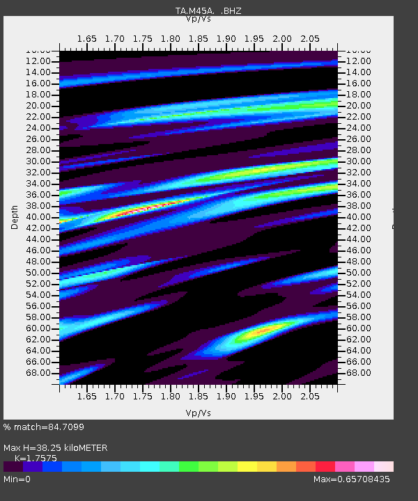
| Estimated Moho Depth: |
38.25 km |
| Estimated Crust Vp/Vs: |
1.76 |
| Assumed Crust Vp: |
6.498 km/s |
| Estimated Crust Vs: |
3.697 km/s |
| Estimated Crust Poisson's Ratio: |
0.26 |
|
| Radial Match: |
84.7099 % |
| Radial Bump: |
366 |
| Transverse Match: |
67.16837 % |
| Transverse Bump: |
400 |
| SOD ConfigId: |
494114 |
| Insert Time: |
2013-05-15 05:18:48.509 +0000 |
| GWidth: |
2.5 |
| Max Bumps: |
400 |
| Tol: |
0.001 |
|

Signal To Noise
| Channel | StoN | STA | LTA |
| TA:M45A: :BHZ:20130228T14:16:40.099976Z | 6.412277 | 2.565337E-6 | 4.0006645E-7 |
| TA:M45A: :BHN:20130228T14:16:40.099976Z | 2.314151 | 9.136584E-7 | 3.9481364E-7 |
| TA:M45A: :BHE:20130228T14:16:40.099976Z | 1.9514791 | 7.585544E-7 | 3.887074E-7 |
| Arrivals |
| Ps | 4.6 SECOND |
| PpPs | 16 SECOND |
| PsPs/PpSs | 20 SECOND |


