You are here: Home > Network List > TA - USArray Transportable Network (new EarthScope stations) Stations List
> Station Q46A CEJHS Indians, Carlisle, IN, USA > Earthquake Result Viewer
Q46A CEJHS Indians, Carlisle, IN, USA - Earthquake Result Viewer
| Earthquake location: |
Kuril Islands |
| Earthquake latitude/longitude: |
51.0/157.3 |
| Earthquake time(UTC): |
2013/02/28 (059) 14:05:50 GMT |
| Earthquake Depth: |
41 km |
| Earthquake Magnitude: |
6.4 MB, 6.7 MS, 6.9 MW, 6.8 MW |
| Earthquake Catalog/Contributor: |
WHDF/NEIC |
|
| Network: |
TA USArray Transportable Network (new EarthScope stations) |
| Station: |
Q46A CEJHS Indians, Carlisle, IN, USA |
| Lat/Lon: |
39.02 N/87.36 W |
| Elevation: |
164 m |
|
| Distance: |
74.1 deg |
| Az: |
47.059 deg |
| Baz: |
323.529 deg |
| Ray Param: |
0.052520547 |
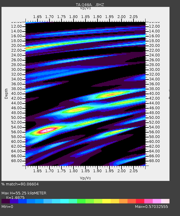
| Estimated Moho Depth: |
55.25 km |
| Estimated Crust Vp/Vs: |
1.69 |
| Assumed Crust Vp: |
6.444 km/s |
| Estimated Crust Vs: |
3.819 km/s |
| Estimated Crust Poisson's Ratio: |
0.23 |
|
| Radial Match: |
90.86604 % |
| Radial Bump: |
385 |
| Transverse Match: |
74.076035 % |
| Transverse Bump: |
400 |
| SOD ConfigId: |
494114 |
| Insert Time: |
2013-05-15 05:19:12.233 +0000 |
| GWidth: |
2.5 |
| Max Bumps: |
400 |
| Tol: |
0.001 |
|

Signal To Noise
| Channel | StoN | STA | LTA |
| TA:Q46A: :BHZ:20130228T14:16:50.974976Z | 10.641208 | 3.432898E-6 | 3.2260417E-7 |
| TA:Q46A: :BHN:20130228T14:16:50.974976Z | 3.3597913 | 1.2128402E-6 | 3.6098677E-7 |
| TA:Q46A: :BHE:20130228T14:16:50.974976Z | 2.6496587 | 9.0128543E-7 | 3.4015153E-7 |
| Arrivals |
| Ps | 6.1 SECOND |
| PpPs | 22 SECOND |
| PsPs/PpSs | 28 SECOND |


