You are here: Home > Network List > TA - USArray Transportable Network (new EarthScope stations) Stations List
> Station T48A Bowling Green, KY, USA > Earthquake Result Viewer
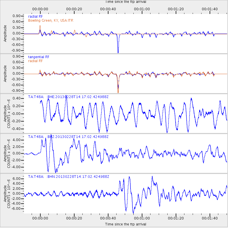
T48A Bowling Green, KY, USA - Earthquake Result Viewer
*The percent match for this event was below the threshold and hence no stack was calculated.
| Earthquake location: |
Kuril Islands |
| Earthquake latitude/longitude: |
51.0/157.3 |
| Earthquake time(UTC): |
2013/02/28 (059) 14:05:50 GMT |
| Earthquake Depth: |
41 km |
| Earthquake Magnitude: |
6.4 MB, 6.7 MS, 6.9 MW, 6.8 MW |
| Earthquake Catalog/Contributor: |
WHDF/NEIC |
|
| Network: |
TA USArray Transportable Network (new EarthScope stations) |
| Station: |
T48A Bowling Green, KY, USA |
| Lat/Lon: |
37.11 N/86.39 W |
| Elevation: |
218 m |
|
| Distance: |
76.0 deg |
| Az: |
47.589 deg |
| Baz: |
324.257 deg |
| Ray Param: |
$rayparam |
*The percent match for this event was below the threshold and hence was not used in the summary stack. |
|
| Radial Match: |
81.06339 % |
| Radial Bump: |
346 |
| Transverse Match: |
80.49177 % |
| Transverse Bump: |
336 |
| SOD ConfigId: |
494114 |
| Insert Time: |
2013-05-15 05:19:34.347 +0000 |
| GWidth: |
2.5 |
| Max Bumps: |
400 |
| Tol: |
0.001 |
|
Signal To Noise
| Channel | StoN | STA | LTA |
| TA:T48A: :BHZ:20130228T14:17:02.424988Z | 13.093187 | 2.8255088E-6 | 2.1579991E-7 |
| TA:T48A: :BHN:20130228T14:17:02.424988Z | 0.68720865 | 4.4818037E-7 | 6.521751E-7 |
| TA:T48A: :BHE:20130228T14:17:02.424988Z | 1.1890178 | 2.2406044E-7 | 1.8844163E-7 |
| Arrivals |
| Ps | |
| PpPs | |
| PsPs/PpSs | |


