You are here: Home > Network List > TA - USArray Transportable Network (new EarthScope stations) Stations List
> Station U47A Clarksville, TN, USA > Earthquake Result Viewer
U47A Clarksville, TN, USA - Earthquake Result Viewer
| Earthquake location: |
Kuril Islands |
| Earthquake latitude/longitude: |
51.0/157.3 |
| Earthquake time(UTC): |
2013/02/28 (059) 14:05:50 GMT |
| Earthquake Depth: |
41 km |
| Earthquake Magnitude: |
6.4 MB, 6.7 MS, 6.9 MW, 6.8 MW |
| Earthquake Catalog/Contributor: |
WHDF/NEIC |
|
| Network: |
TA USArray Transportable Network (new EarthScope stations) |
| Station: |
U47A Clarksville, TN, USA |
| Lat/Lon: |
36.44 N/87.29 W |
| Elevation: |
145 m |
|
| Distance: |
76.2 deg |
| Az: |
48.591 deg |
| Baz: |
323.965 deg |
| Ray Param: |
0.051108986 |
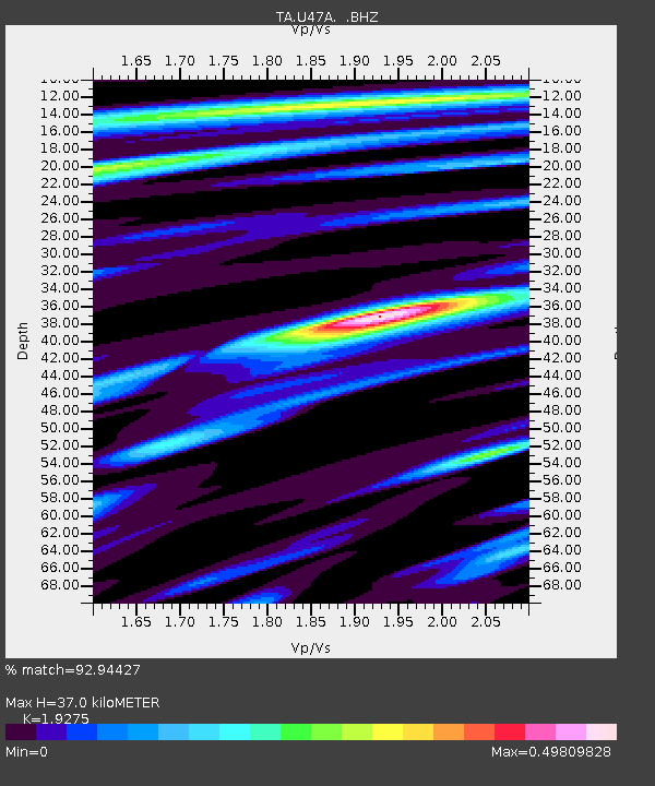
| Estimated Moho Depth: |
37.0 km |
| Estimated Crust Vp/Vs: |
1.93 |
| Assumed Crust Vp: |
6.444 km/s |
| Estimated Crust Vs: |
3.343 km/s |
| Estimated Crust Poisson's Ratio: |
0.32 |
|
| Radial Match: |
92.94427 % |
| Radial Bump: |
328 |
| Transverse Match: |
84.601616 % |
| Transverse Bump: |
400 |
| SOD ConfigId: |
494114 |
| Insert Time: |
2013-05-15 05:20:08.331 +0000 |
| GWidth: |
2.5 |
| Max Bumps: |
400 |
| Tol: |
0.001 |
|

Signal To Noise
| Channel | StoN | STA | LTA |
| TA:U47A: :BHZ:20130228T14:17:03.099976Z | 20.022493 | 3.4441578E-6 | 1.7201442E-7 |
| TA:U47A: :BHN:20130228T14:17:03.099976Z | 3.2767224 | 9.592301E-7 | 2.927407E-7 |
| TA:U47A: :BHE:20130228T14:17:03.099976Z | 5.518692 | 9.939523E-7 | 1.8010651E-7 |
| Arrivals |
| Ps | 5.5 SECOND |
| PpPs | 16 SECOND |
| PsPs/PpSs | 22 SECOND |


