You are here: Home > Network List > TA - USArray Transportable Network (new EarthScope stations) Stations List
> Station R48A Northridge Ranch, Floyd Knobs, IN, USA > Earthquake Result Viewer
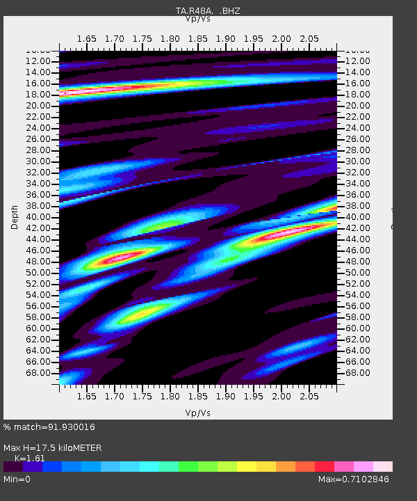
R48A Northridge Ranch, Floyd Knobs, IN, USA - Earthquake Result Viewer
| Earthquake location: |
Kuril Islands |
| Earthquake latitude/longitude: |
51.0/157.3 |
| Earthquake time(UTC): |
2013/02/28 (059) 14:05:50 GMT |
| Earthquake Depth: |
41 km |
| Earthquake Magnitude: |
6.4 MB, 6.7 MS, 6.9 MW, 6.8 MW |
| Earthquake Catalog/Contributor: |
WHDF/NEIC |
|
| Network: |
TA USArray Transportable Network (new EarthScope stations) |
| Station: |
R48A Northridge Ranch, Floyd Knobs, IN, USA |
| Lat/Lon: |
38.40 N/85.87 W |
| Elevation: |
243 m |
|
| Distance: |
75.2 deg |
| Az: |
46.465 deg |
| Baz: |
324.297 deg |
| Ray Param: |
0.051731687 |
| Estimated Moho Depth: |
17.5 km |
| Estimated Crust Vp/Vs: |
1.61 |
| Assumed Crust Vp: |
6.498 km/s |
| Estimated Crust Vs: |
4.036 km/s |
| Estimated Crust Poisson's Ratio: |
0.19 |
|
| Radial Match: |
91.930016 % |
| Radial Bump: |
375 |
| Transverse Match: |
69.33725 % |
| Transverse Bump: |
400 |
| SOD ConfigId: |
494114 |
| Insert Time: |
2013-05-15 05:20:29.299 +0000 |
| GWidth: |
2.5 |
| Max Bumps: |
400 |
| Tol: |
0.001 |
|

Signal To Noise
| Channel | StoN | STA | LTA |
| TA:R48A: :BHZ:20130228T14:16:57.825012Z | 9.759528 | 3.7125403E-6 | 3.8040164E-7 |
| TA:R48A: :BHN:20130228T14:16:57.825012Z | 4.111578 | 1.2424617E-6 | 3.0218612E-7 |
| TA:R48A: :BHE:20130228T14:16:57.825012Z | 3.9711874 | 9.998316E-7 | 2.5177147E-7 |
| Arrivals |
| Ps | 1.7 SECOND |
| PpPs | 6.8 SECOND |
| PsPs/PpSs | 8.5 SECOND |


