You are here: Home > Network List > TA - USArray Transportable Network (new EarthScope stations) Stations List
> Station Y48A Jasper, AL, USA > Earthquake Result Viewer
Y48A Jasper, AL, USA - Earthquake Result Viewer
| Earthquake location: |
Kuril Islands |
| Earthquake latitude/longitude: |
51.0/157.3 |
| Earthquake time(UTC): |
2013/02/28 (059) 14:05:50 GMT |
| Earthquake Depth: |
41 km |
| Earthquake Magnitude: |
6.4 MB, 6.7 MS, 6.9 MW, 6.8 MW |
| Earthquake Catalog/Contributor: |
WHDF/NEIC |
|
| Network: |
TA USArray Transportable Network (new EarthScope stations) |
| Station: |
Y48A Jasper, AL, USA |
| Lat/Lon: |
33.91 N/87.17 W |
| Elevation: |
170 m |
|
| Distance: |
78.3 deg |
| Az: |
50.024 deg |
| Baz: |
324.35 deg |
| Ray Param: |
0.04969035 |
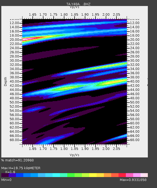
| Estimated Moho Depth: |
19.75 km |
| Estimated Crust Vp/Vs: |
1.60 |
| Assumed Crust Vp: |
6.565 km/s |
| Estimated Crust Vs: |
4.103 km/s |
| Estimated Crust Poisson's Ratio: |
0.18 |
|
| Radial Match: |
91.20968 % |
| Radial Bump: |
349 |
| Transverse Match: |
74.36881 % |
| Transverse Bump: |
400 |
| SOD ConfigId: |
494114 |
| Insert Time: |
2013-05-15 05:21:03.308 +0000 |
| GWidth: |
2.5 |
| Max Bumps: |
400 |
| Tol: |
0.001 |
|
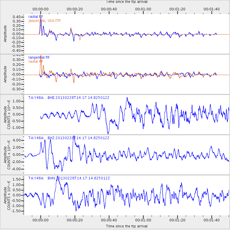
Signal To Noise
| Channel | StoN | STA | LTA |
| TA:Y48A: :BHZ:20130228T14:17:14.825012Z | 7.6494327 | 2.3224732E-6 | 3.0361377E-7 |
| TA:Y48A: :BHN:20130228T14:17:14.825012Z | 2.9797292 | 5.5491984E-7 | 1.8623165E-7 |
| TA:Y48A: :BHE:20130228T14:17:14.825012Z | 2.4797122 | 4.5318234E-7 | 1.8275603E-7 |
| Arrivals |
| Ps | 1.9 SECOND |
| PpPs | 7.6 SECOND |
| PsPs/PpSs | 9.4 SECOND |


