You are here: Home > Network List > TA - USArray Transportable Network (new EarthScope stations) Stations List
> Station 149A Jones, AL, USA > Earthquake Result Viewer
149A Jones, AL, USA - Earthquake Result Viewer
| Earthquake location: |
Kuril Islands |
| Earthquake latitude/longitude: |
51.0/157.3 |
| Earthquake time(UTC): |
2013/02/28 (059) 14:05:50 GMT |
| Earthquake Depth: |
41 km |
| Earthquake Magnitude: |
6.4 MB, 6.7 MS, 6.9 MW, 6.8 MW |
| Earthquake Catalog/Contributor: |
WHDF/NEIC |
|
| Network: |
TA USArray Transportable Network (new EarthScope stations) |
| Station: |
149A Jones, AL, USA |
| Lat/Lon: |
32.60 N/86.79 W |
| Elevation: |
138 m |
|
| Distance: |
79.5 deg |
| Az: |
50.537 deg |
| Baz: |
324.655 deg |
| Ray Param: |
0.048838872 |
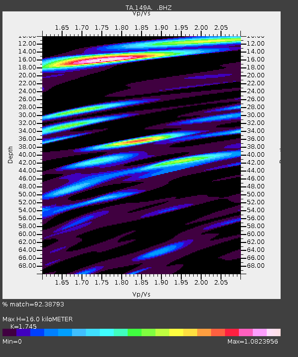
| Estimated Moho Depth: |
16.0 km |
| Estimated Crust Vp/Vs: |
1.75 |
| Assumed Crust Vp: |
6.565 km/s |
| Estimated Crust Vs: |
3.762 km/s |
| Estimated Crust Poisson's Ratio: |
0.26 |
|
| Radial Match: |
92.38793 % |
| Radial Bump: |
400 |
| Transverse Match: |
78.525024 % |
| Transverse Bump: |
400 |
| SOD ConfigId: |
494114 |
| Insert Time: |
2013-05-15 05:21:37.993 +0000 |
| GWidth: |
2.5 |
| Max Bumps: |
400 |
| Tol: |
0.001 |
|

Signal To Noise
| Channel | StoN | STA | LTA |
| TA:149A: :BHZ:20130228T14:17:21.674988Z | 6.8190603 | 3.2501164E-6 | 4.7662232E-7 |
| TA:149A: :BHN:20130228T14:17:21.674988Z | 1.8906404 | 1.7683535E-6 | 9.353198E-7 |
| TA:149A: :BHE:20130228T14:17:21.674988Z | 1.3635699 | 9.610624E-7 | 7.0481343E-7 |
| Arrivals |
| Ps | 1.9 SECOND |
| PpPs | 6.5 SECOND |
| PsPs/PpSs | 8.4 SECOND |


