You are here: Home > Network List > TA - USArray Transportable Network (new EarthScope stations) Stations List
> Station 454A Quitman, GA, USA > Earthquake Result Viewer
454A Quitman, GA, USA - Earthquake Result Viewer
| Earthquake location: |
Kuril Islands |
| Earthquake latitude/longitude: |
51.0/157.3 |
| Earthquake time(UTC): |
2013/02/28 (059) 14:05:50 GMT |
| Earthquake Depth: |
41 km |
| Earthquake Magnitude: |
6.4 MB, 6.7 MS, 6.9 MW, 6.8 MW |
| Earthquake Catalog/Contributor: |
WHDF/NEIC |
|
| Network: |
TA USArray Transportable Network (new EarthScope stations) |
| Station: |
454A Quitman, GA, USA |
| Lat/Lon: |
30.71 N/83.63 W |
| Elevation: |
50 m |
|
| Distance: |
82.6 deg |
| Az: |
49.37 deg |
| Baz: |
326.126 deg |
| Ray Param: |
0.04671371 |
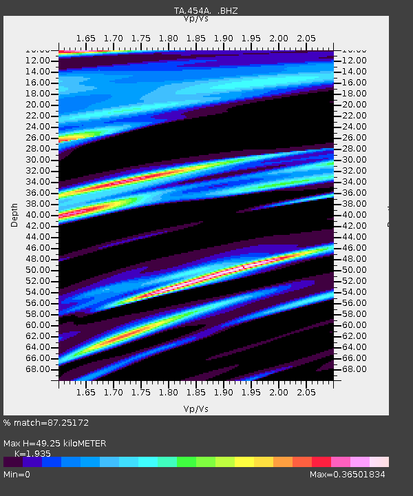
| Estimated Moho Depth: |
49.25 km |
| Estimated Crust Vp/Vs: |
1.93 |
| Assumed Crust Vp: |
6.565 km/s |
| Estimated Crust Vs: |
3.393 km/s |
| Estimated Crust Poisson's Ratio: |
0.32 |
|
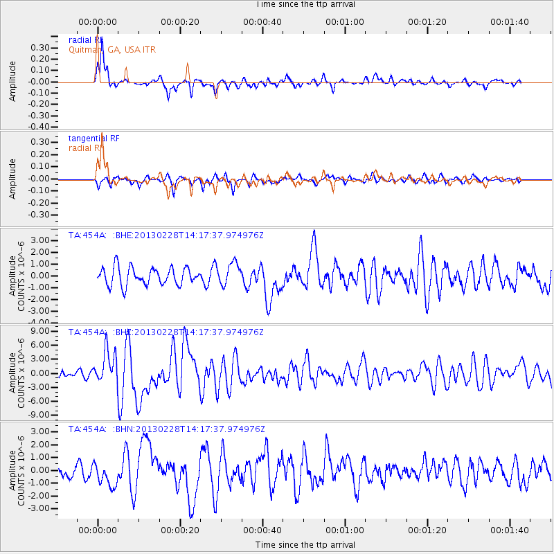
| Radial Match: |
87.25172 % |
| Radial Bump: |
317 |
| Transverse Match: |
61.27221 % |
| Transverse Bump: |
378 |
| SOD ConfigId: |
494114 |
| Insert Time: |
2013-05-15 05:23:22.432 +0000 |
| GWidth: |
2.5 |
| Max Bumps: |
400 |
| Tol: |
0.001 |
|
Signal To Noise
| Channel | StoN | STA | LTA |
| TA:454A: :BHZ:20130228T14:17:37.974976Z | 3.4862535 | 3.647488E-6 | 1.0462486E-6 |
| TA:454A: :BHN:20130228T14:17:37.974976Z | 2.338547 | 9.509511E-7 | 4.0664185E-7 |
| TA:454A: :BHE:20130228T14:17:37.974976Z | 1.2620702 | 9.380477E-7 | 7.432611E-7 |
| Arrivals |
| Ps | 7.2 SECOND |
| PpPs | 21 SECOND |
| PsPs/PpSs | 29 SECOND |


